Hachimanyama Kofun (Maebashi)
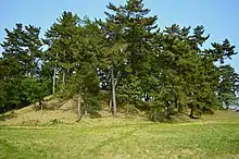
The Hachimanyama Kofun (八幡山古墳) is a Kofun period keyhole-shaped burial mound located in what is now the Asakura neighborhood of the city of Maebashi, Gunma Prefecture in the northern Kantō region of Japan. It was designated a National Historic Site of Japan in 1949.[1]It is one of the Asakura-Hirose Kofun Cluster of over 150 tumuli from the 4th to 6th century in the foothills of Mount Akagi, which also includes the Maebashi Futagoyama Kofun.
八幡山古墳 | |
 Hachimanyama Kofun | |
 Hachimanyama Kofun  Hachimanyama Kofun (Maebashi) (Japan) | |
| Location | Maebashi, Gunma, Japan |
|---|---|
| Region | Kantō region |
| Coordinates | 36°22′01″N 139°06′04″E |
| Type | kofun |
| History | |
| Founded | late 4th century |
| Periods | Kofun period |
| Site notes | |
| Public access | Yes (Park) |
Overview
The Hachimanyama Kofun is located almost parallel to the right bank of the Hirose River, and is orientated facing southeast. It has a total length of 130 meters, making it one of the largest in the Kantō region. It can be dated to the latter half of the 4th century due to a layer of pumice ash that was deposited by an eruption of Mount Asama found under the tumulus. The surface was originally covered in fukiishi, some of which towards the bottom of the mound are unusually large. No haniwa have been uncovered. The tumulus appears to have had a shallow moat with a width fo 25 to 30 meters. Although the detailed structure of the mound has not been investigated yet, it is believed to have a gravel-lined burial chamber. Due to finds in ongoing investigations, the area covered by the National Historic Site designation was extended in 1980, again in 2003, and again in 2020
- Overall length: 130 meters
- Posterior circle: 72 meter diameter x 12 meters high
- Anterior portion: 59 meter width x 8 meters high
References
- "八幡山古墳" (in Japanese). Agency for Cultural Affairs. Retrieved August 20, 2020.
External links
![]() Media related to Maebashi-hachimanyama-kofun at Wikimedia Commons
Media related to Maebashi-hachimanyama-kofun at Wikimedia Commons
- Maebashi City official guide (in Japanese)