Hadsund Syd
Hadsund South (Danish:Hadsund Syd) (originally Sønder Hadsund) lies 252 meters south of the city of Hadsund, adjoined to the rest of the city by the Hadsund bridge. Due to this specific distance to the rest of the city proper, it is classified as an "independent urban area" by Statistics Denmark. As of the 1st of January 2020, the area has a population of 457.,[1] with the area receiving mention under various placenames since at least 1436, when it was first recognized. Today, Hadsund South Station and the Ferry Inn Hotel (Færgekroen) is located in Hadsund South.
.JPG.webp)
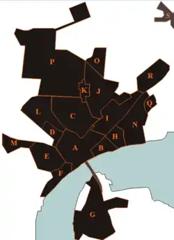
A: Hadsund Center
B: Munchs eng
C: Rosendal
D: Himmerlandsgade (district)
E: Pip-district
F: Forest-kvarteret
G: Hadsund South
H: Ved Stranden
I: Island-district
J: Holterne
K: Søndergårde
L: Hadsund Huse
M: Højmarken
N: Rolighed
O: Bøgelunden
P: Industrial North
Q: Molhøj
R: Industrial East
History
The first credible mention of Hadsund South in written records appears in 1579 as "Hassond ferresstedtt" [2] after the inn who prepared the ferry site (today Færgekroen). However, other names have also been attributed to the area, such as "Hadsund Husene", dating to at least 1736 and lasting until 1880.
Originally, the ferry inn and local jetty constituted the entire settlement area jetty. However, justification for a tangible population in Hadsund South was only brought by the advent of the railway much later, with boarding access provided by the railway station. This soon spurred industrial development in the area which provided a means of living for the local residents.[3]
External links
 Media related to Hadsund Syd at Wikimedia Commons
- Mariagerfjord municipality's official website) (in Danish)
- Hadsund Trade association
- a page about Hadsund
References
- BY3: Population 1. January by urban areas The Mobile Statbank from Statistics Denmark
- http://danmarksstednavne.navneforskning.ku.dk/
- Hadsund – fra ladested til industriby 1983, s. 4-6
- Municipal statistics: NetBorger Kommunefakta, delivered from KMD aka Kommunedata (Municipal Data)
- Municipal mergers and neighbors: Eniro new municipalities map
- Hadsund – fra ladested til industriby 1983, s. 4-6