Harsil
Harsil, also known as the Mini Switzerland of India,[1] is a village, located on the banks of the Bhagirathi River, on the way to Gangotri, a Hindu pilgrimage site in Uttarkashi district of the Indian state of Uttarakhand.

Harsil | |
|---|---|
village | |
 Harsil Location in Uttarakhand, India | |
| Coordinates: 31°02′N 78°44′E | |
| Country | |
| State | Uttarakhand |
| Elevation | 2,745 m (9,006 ft) |
| Languages | |
| • Official | Hindi |
| Time zone | UTC+5:30 (IST) |
| Vehicle registration | UK |
| Website | uk |
Situated at an altitude of 9,005 ft (2,745 metres.) from sea level, Harsil lies 78 km. from Uttarkashi, and 30 km away from the Gangotri National Park which is spread across 1,553 square km. The hill station is well- known for its natural environment and apple production.[2]
Geography
Harsil is connected with the Baspa valley by several passes including the Lamkhaga Pass. The village lies on the old caravan trail between Tibet Autonomous Region and India, where trade & marriages once flourished.
Etymology
A local legend says that Harsil got its name from the rivers Bhagirathi and the Jalandhari as once they had an argument over their significance. Lord Vishnu, also known as Hari, was asked to intervene. He turned himself into a great stone, a shila, and absorbed their anger. Even today, after Hari-shila (or Harsil), the waters of the two rivers have become a little less turbulent.[3]

Demographic
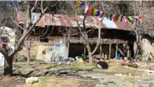
Over the years, a small number of Jadhs, an ethnic group of the Bhotiyas, have settled here, and speak a language closely resembling Tibetan. There is also a sizeable Tibetan settlement in a close vicinity to ITPB Campus housing a Stupa (Buddhist Burial Mound) and beautifully carved wooden houses. [4]
Pilgrimage
The idol of the Hindu River Goddess Ganga (Ganges) is brought down from the shrine at Gangotri in the upper Himalayas after Diwali and kept at 'Mukhba' village near Harsil. It remains there throughout the winter when Gangotri is snowbound and inaccessible.[5]
Army area
It is an army area, not a permanent cantonment. It is a base camp of "The Garhwal Scouts" and "Indo-Tibetan Border Police (ITBP)". Despite being a small army area, it is very important because of its nearness to China Border. On 6 November 2018, Prime Minister Narendra Modi visited Harsil to celebrate Diwali with ITBP Jawans.[6]
Defence Agricultural Research Laboratory
A detachment of the Defence Agricultural Research Laboratory run by the Defence Research and Development Organisation (DRDO), was established here in May 1973.
References
- Planet, Lonely. "Harsil- a mini Switzerland in Uttarakhand". Lonely Planet India. Retrieved 8 July 2020.
- "Uttarakhand's 'Harsil Apple Festival' bears' fruit". The New Indian Express. Retrieved 8 July 2020.
- Sharma, Dheeraj (2 December 2019). "Harsil - An Offbeat Place in Garhwal, Uttarakhand". Devil On Wheels™. Retrieved 15 July 2020.
- "Travel lessons on a trip to Gangotri via a Tibetan settlement". SandeepaChetan's Travel Blog. 9 October 2017. Retrieved 7 July 2020.
- "Mukhba Valley Travel Guide – Mukhba Village Location How to Reach Mukhba". www.euttaranchal.com. Retrieved 8 July 2020.
- "PM Modi to celebrate Diwali at Harsil with ITBP Jawans". United News of India. 6 November 2018. Retrieved 9 July 2020.