Hers-Vif
The Hers-Vif ("Live Hers", as opposed to the slower flowing Hers-Mort, "Dead Hers"), also named Grand Hers or simply Hers, is a 135-kilometre (84 mi) long river in southern France, right tributary of the Ariège.[1]
| Hers-Vif | |
|---|---|
.JPG.webp) | |
 | |
| Location | |
| Country | France |
| Physical characteristics | |
| Source | |
| • location | Pyrenees |
| • elevation | ±1,500 m (4,900 ft) |
| Mouth | |
• location | Ariège |
• coordinates | 43°18′21″N 1°33′9″E |
| Length | 135 km (84 mi) |
| Basin size | 1,350 km2 (520 sq mi) |
| Discharge | |
| • average | 15 m3/s (530 cu ft/s) |
| Basin features | |
| Progression | Ariège→ Garonne→ Gironde estuary→ Atlantic Ocean |
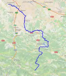
The Hers-Vif rises at an elevation of about 1,500 metres (4,900 ft) near the Chioula Pass of the Pyrenees, approximately 6 kilometres (4 mi) north of Ax-les-Thermes. It is the major tributary of the Ariège into whose right bank it flows 2 kilometres (1.2 mi) upstream from Cintegabelle in the Haute-Garonne.
It flows some 30 kilometres (19 mi) through the Pyrenees, descending 1,100 metres (3,600 ft) to the village of Peyrat, where it reaches a piedmont plain. Its valley widens as it traverses the plain, reaching the medieval city of Mirepoix, which marks the start of its lower valley.
Several rivers flow into it:
- From the Pyrenees: the Lasset; the Fontaine de Fontestorbes; the Touyre
- From the piedmont plain and hills: the Blau and the Douctouyre;
- From the hills of Lauragais and Razès: the Ambronne and the Vixiège.
Departments and towns along its course are:
Floods
The Hers is probably known as vif (intense or rapid in this context) because of its sometimes spectacular floods – that of 16 June 1289 having entirely destroyed Mirepoix. More recently, there have been:
- 23 June 1875: estimated flow rate of 1,500 cubic metres per second (53,000 cu ft/s) at Mazères;
- 6 February 1919: estimated flow rate of 600 to 800 cubic metres per second (21,000 to 28,000 cu ft/s) at Mazères;
- 19 May 1977: estimated flow rate of 1,070 cubic metres per second (38,000 cu ft/s) at Mazères;
- 16 January 1981: estimated flow rate of 1,100 cubic metres per second (39,000 cu ft/s) at Mazères;
- 11 June 2000: estimated flow rate of 500 cubic metres per second (18,000 cu ft/s) at Mazères;
- 24 January 2004: estimated flow rate of 500 cubic metres per second (18,000 cu ft/s) at Mazères.