Hills and mountains of the Isle of Man
The Isle of Man is mostly hilly, but has only one summit, Snaefell, classified as a mountain (over 2,000 feet).

Overview
The south of the island has a small coastal plain around Castletown and Ballasalla but is otherwise hilly. In the south west these hills rise to more prominent peaks, notably South Barrule (483 m), and Cronk ny Arrey Laa (437 m) which drops almost vertically into the sea.[1]
A central valley separates the southern hills from the central range which contains the highest peaks. This central range contains 11 out of 12 of the Island's highest peaks. It has open moorland and rough terrain. It is very sparsely populated and has just one major road crossing it except along the coast.[1]
This then drops quite suddenly to a large flat northern glacial till plain which has only small rolling hills (max. 96 m) known as the Bride hills.[1]
Marilyns
The Isle of Man contains five Marilyns:
| Peak | Height (m) | Prom. (m) | Key col (m) | Grid ref. | Parent |
|---|---|---|---|---|---|
| Snaefell | 621 | 621 | Sea | SC397881 | none, highest peak in the Isle of Man |
| South Barrule | 483 | 436 | 47 | SC257759 | Snaefell |
| Bradda Hill | 230 | 193 | 37 | SC193711 | South Barrule |
| Slieau Freoaghane | 488 | 153 | 335 | SC340883 | Snaefell |
| Mull Hill | 169 | 151 | 18 | SC189676 | Bradda Hill |
List of peaks over 1,500 feet (457 m)
The Isle of Man contains 11 peaks which stand at over 1,500 ft.[2] All of these, except for the South Barrule (in the south) are found in the central range which spans the region between the central valley and the flat fertile northern plain. Although none of these peaks are especially high, they appear quite prominent and impressive due to their proximity to the sea. Whilst many of these peaks are rugged, they are not steep enough to provide many opportunities for technical climbing (which can be found in abundance around the coast). There are opportunities for scrambling in some areas, including the northern slopes of the North Barrule, around the Sloc, and the southern slopes of Greeba Mountain. These can provide a training ground for the higher steeper mountains in places such as Snowdonia and the Highlands of Scotland; they are also far less crowded than some of Britain's more popular hill destinations. All of these peaks can be reached by a rough hill walk.
| Hill | Height (ft) | Height (m) | Grid ref. | Area |
|---|---|---|---|---|
| Snaefell | 2,037 | 621 | 397881 | Central |
| North Barrule | 1,854 | 565 | 443909 | North East |
| Clagh Ouyr | 1,808 | 551 | 415890 | North East |
| Beinn-y-Phott | 1,785 | 544 | 381861 | Central |
| Slieau Freoaghane | 1,601 | 488 | 341883 | Michael Hills |
| Colden | 1,598 | 487 | 343843 | Central |
| South Barrule | 1,585 | 483 | 258759 | South West |
| Slieau Ruy | 1,572 | 479 | 329824 | Central |
| Sartfell | 1,490 | 454 | 335872 | Michael Hills |
| Carraghyn | 1,640 | 500 | 370850 | Central |
| Slieau Lhean | 1,539 | 469 | 426877 | East |
Additional heights above 1500 feet include Mullagh Ouyr (gr 398861) and two unnamed points on the ridge between Clagh Ouyr and the North Barrule (gr 425900 & 432904).
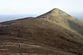 North Barrule
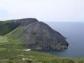 Bradda hill in the south
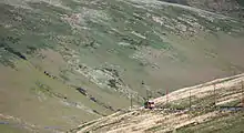 The railway to the summit of Snaefell
References
- http://www.isle-of-man.com/manxnotebook/
- "Archived copy". Archived from the original on 2008-09-28. Retrieved 2009-08-17.CS1 maint: archived copy as title (link)