Himatangi Beach
Himatangi Beach is a small coastal community in the Manawatū-Whanganui region of New Zealand's North Island. It is located 32 kilometres west of Palmerston North In the centre of the largest sand dune geographical feature in New Zealand.[1]
Himatangi Beach | |
|---|---|
Town | |
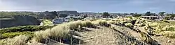 Himatangi Beach and Kaikokopu Stream from the dunes | |
| Coordinates: 40°22′18″S 175°14′06″E | |
| Country | New Zealand |
| Region | Manawatū-Whanganui |
| Settled | Early 1700s |
| Area | |
| • Total | 0.95 km2 (0.37 sq mi) |
| Population (2006) | |
| • Total | 435 |
| • Density | 457/km2 (1,180/sq mi) |
| Time zone | UTC-12 (NZST) |
| Postal code | 5551 |
| Area code(s) | Area codes 329 |
| Website | http://www.himatangi-beach.gen.nz |
Demographics
The community has a population of around 600, increasing to several thousand in the summer.
| Year | Population | Average age | Households | Average income | National average |
|---|---|---|---|---|---|
| 2001 | 540 | 41.8 | 234 | $13,000 | $18,500 |
| 2006 | 450 | 40.8 | 189 | $17,900 | $24,100 |
| 2013 | 429 | 49.1 | 189 | $20,800 | $27,900[2] |
In 2013 there were 225 unoccupied dwellings, 68.3% were owner occupiers, 11.6% were unemployed, 7.4% held a degree and 19.4% of the population were Māori.[3] Most are employed locally, or in Palmerston North, or Foxton.[4]
See also
References
| Wikimedia Commons has media related to Himatangi Beach. |
- Himatangi Beach web site
- "2013 Census map – QuickStats about a place". archive.stats.govt.nz. Retrieved 19 January 2020.
- "2013 Census QuickStats about a place". archive.stats.govt.nz. Retrieved 19 January 2020.
- "SNZ Commuter View". archive.stats.govt.nz. Retrieved 19 January 2020.
This article is issued from Wikipedia. The text is licensed under Creative Commons - Attribution - Sharealike. Additional terms may apply for the media files.