Horsenden Hill
Horsenden Hill (/ˈhɔːrsəndən/; grid reference TQ 161 843) is a hill and open space, located between the Perivale, Sudbury, and Greenford areas of West London. It is in the London Borough of Ealing, close to the boundary with the London Borough of Brent. It is one of the higher eminences in the local area, rising to 85m (276 ft) above sea level, and the summit forms part of the site of an ancient hillfort. It is the site of a trig point, TP4024.

Formation and History
The hill rises from a base of London Clay at around 60m altitude. Above that is an isolated layer of sandier Claygate Beds. Both are of Eocene age, dated at about 50 million years ago.
Around the very summit is a small and relatively thin layer of much younger Dollis Hill Gravel. This permeable gravel has to some extent protected the London Clay below from being eroded away. It is not uncommon to find hills in the London area which are capped by a protective layer of sand or gravel, with London Clay below - another example is Barn Hill (Wembley), to the north-east. Barn Hill also has a cap of Dollis Hill Gravel. So too does Dollis Hill itself.
The Dollis Hill Gravel was deposited more than half a million years ago by a river which flowed from well to the south and continued to the north-east. This is known because about 7% of the gravel, which is otherwise composed mostly of flint, consists of a hard stone called chert, which can only come from Lower Greensand beds found to the south in Surrey.[1] The river was perhaps an ancestor of the River Wey in Surrey.
This gravel was probably a much more extensive deposit in this part of the London area than it is now.
The river which deposited the Dollis Hill Gravel at Horsenden Hill eventually flowed into the River Thames around Hoddesdon in Hertfordshire. At that time, the Thames was itself flowing on a course different from today's, roughly on a line through Burnham Beeches, St Albans, Harlow, Colchester and Ipswich.
Approximately 450,000 years ago, ice from northern Britain reached as far south as north London. A lobe of this ice advanced up the valley whose river had previously deposited the Dollis Hill Gravel.
As the ice moved up the valley (it eventually reached at least as far as Finchley), the water being brought from the south by the river was blocked. It also encountered meltwater streaming out of the front of the ice sheet. So a huge lake developed in front of the advancing ice sheet.[2]
Eventually, the water in the lake rose to the level of the watershed to the east, which seems to have run approximately south from Hampstead Heath.
To the west, the River Thames also became blocked by the advancing ice sheet. Another lake developed there, with its water rising to a watershed near Uxbridge.
Both watersheds were breached by the rising water. In what must have been a spectacular sight, water poured out towards the east. The two rivers became one and passed through Richmond,[3] then headed towards central London, roughly along the present course of the River Thames.
The lake in front of the Finchley ice sheet became drained. But prior to that, during the time that it rose and fell and swirled around, the lake must have caused a lot of erosion. In particular, it must have removed a lot of the Dollis Hill Gravel in this area. It left isolated hills like Horsenden Hill and Barn Hill, capped by small remnants of the gravel.
So, if Horsenden Hill today resembles an island in a lake which has since dried out, it is because that is a reasonable description of what it actually is.
It is known that 2500 years ago Iron Age people settled on what today is called Horsenden Hill as large amounts of pottery have been discovered. In fact, in 1978 the Iron Age settlement on Horsenden Hill was declared as an Ancient Scheduled monument by English Heritage.
It was probably during Saxon times that the hill acquired its name originally "Horsingdon" - the last syllable don meaning hill fortress.
In the Second World War the hill was the site of an anti-aircraft battery, which was used to protect the local factories from air attack. There are currently two disused reservoirs built into the hill on the south side.
Layout
To the south and east the hill is bound by the Grand Union Canal (Paddington branch), which runs roughly along the 100 ft (30 m) contour line.
To the south west lies Perivale Wood Local Nature Reserve, run and maintained by the Selborne Society. A scenic spot on the Capital Ring in the summer months, Horsenden Hill offers fine views across west London, northwest London and beyond; places visible include Harrow on the Hill, the new Wembley Stadium, Northala Fields, planes coming in to land at Heathrow Airport, and on a clear day, the Home Counties of Surrey, Berkshire and Buckinghamshire.
Two golf courses cover parts of the hill on the south and east sides. Nearby stations are Perivale tube, Sudbury Town tube and Greenford tube and rail stations. There is also a visitors centre located at Horsenden Farm on the east side of the hill and a public car park on the north side. The visitors centre closes at dusk. Access to both is via Horsenden Lane in North Greenford.
In the summer of 2006, as part of the Horsenden Grazing Project, Highland cows were introduced to graze in a fenced-off area. Various other breeds of cow have subsequently been used.
Gallery
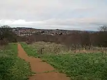
.jpg.webp) Horsenden Hill
Horsenden Hill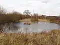 Pond
Pond Trig point
.jpg.webp) Horsenden Hill
Horsenden Hill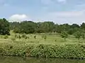 Sudbury Golf Course
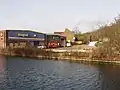 Commercial buildings by the canal at Horsenden Hill
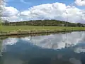 The summit of Horsenden Hill can be seen behind the rugby fields
 Horsenden Lane cuts through the area
References
- http://londongeopartnership.org.uk/wp/wp-content/uploads/2018/08/GLA20.pdf
- Middle Pleistocene drainage in the Thames valley, P. L. Gibbard, Geological Magazine Volume 116, Issue 1 January 1979
- Quaternary River Diversions in the London Basin and the Eastern English Channel, D. R. Bridgland et P. L. Gibbard, Geographie Physique et Quaternaire Volume 51, numéro 3, January 1997
External links
- A view of Horsenden Hill from the canal
- Horsenden Hill hillfort entry at megalithic.co.uk
- Horsenden Hill trigpoint entry at trigpointinguk.com
- A set of photos of Horsenden Hill
- Perivale Wood Local Nature Reserve