Huaytapallana
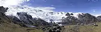
Huaytapallana (possibly from in the Quechua spelling Waytapallana; wayta wild flower, a little bunch of flowers, pallay to collect, pallana an instrument to collect fruit / collectable, Waytapallana "a place where you collect wild flowers",[1][2]) or Lasuntay is the highest peak in the Huaytapallana mountain range in the Andes of Peru.[3] Its summit reaches about 5,557 m (18,232 ft) above sea level. The mountain is situated in the Junín Region, Huancayo Province, in the districts of Huancayo and Pariahuanca.[4]
| Huaytapallana | |
|---|---|
 | |
| Highest point | |
| Elevation | 5,557 m (18,232 ft) |
| Listing | List of mountains in the Andes |
| Coordinates | 11°54′29″S 75°03′15″W |
| Geography | |
 Huaytapallana Peru | |
| Location | Peru, Junín Region, Huancayo Province, Huancayo District, Pariahuanca District |
| Parent range | Andes, Huaytapallana |
References
- Teofilo Laime Ajacopa, Diccionario Bilingüe Iskay simipi yuyayk'ancha, La Paz, 2007 (Quechua-Spanish dictionary)
- Diccionario Quechua - Español - Quechua, Academía Mayor de la Lengua Quechua, Gobierno Regional Cusco, Cusco 2005 (Quechua_Spanish dictionary)
- Evelio Echevarría, Cordillera Huaytapallana, Peru, in: The Alpine Journal, 2009, p. 161-167
- escale.minedu.gob.pe - UGEL map of the Huancayo Province (Junín Region)
This article is issued from Wikipedia. The text is licensed under Creative Commons - Attribution - Sharealike. Additional terms may apply for the media files.