Hurtle Square
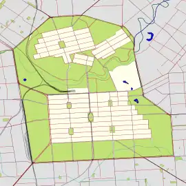
Hurtle Square, also known as Tangkaira, is one of five public squares in the Adelaide city centre, South Australia. Located in the centre of the south-eastern quarter of the city, it surrounds the intersection of Halifax and Pulteney Streets. Its north edge is bounded by Carrington Street.
| Hurtle Square | |
|---|---|
| Tangkaira | |
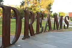 The last word of "THE FOREST OF DREAMS", which encircles the Halifax/Pulteney intersection | |
 | |
| Type | Square |
| Location | Adelaide, South Australia, Australia |
| Coordinates | 34.9322°S 138.6063°E |
| Created | 1837 |
It is one of six squares designed by the founder of Adelaide, Colonel William Light, who was Surveyor-General at the time, in his 1837 plan of the City of Adelaide which spanned the River Torrens Valley, comprising the city centre (South Adelaide) and North Adelaide. The square was named in 1837 by the Street Naming Committee after James Hurtle Fisher, South Australia's first Resident Commissioner, in 2003 assigned a second name in the language of the original inhabitants, Kaurna, Tangkaira, as part of the dual naming initiative by the Adelaide City Council.
History
The street naming committee named the square after James Hurtle Fisher, South Australia's first Resident Commissioner, on 23 May 1837.[1][2]
In March 2003, as part of the City of Adelaide's dual naming project in association with the University of Adelaide's project, the square was assigned the name "Tangkaira", which means "fungus" (King Rodney's wife).[3] Tangkaira, also known as Charlotte, was from the Clare district. She was the wife of Ityamai-itpina (aka "King Rodney"), a key negotiator with the new colonists, and also helped to later provide an important source for reviving the Kaurna language in recent times: she wrote one of the earliest examples of the written Kaurna language, a letter by school children to Governor Gawler in 1841, pleading with him to continue working as Governor.[4]
Description
Located in the centre of the south-eastern quarter of the city, the Square surrounds the intersection of Halifax and Pulteney Streets, with its northern edge is bounded by Carrington Street. The surrounding area is mostly residential.
See also
References
- "Nomenclature of the Streets of Adelaide and North Adelaide" (PDF). State Library of South Australia. Retrieved 14 December 2019.
taken from The City of Adelaide Year Book, 1939-1940
Cite journal requires|journal=(help) - "History of Adelaide Through Street Names". History of South Australia website. Archived from the original on 14 June 2008. Retrieved 25 July 2008.
- "Kaurna Placename Meanings within the City of Adelaide". University of Adelaide. Kaurna Warra Pintyanthi. 27 November 2019. Retrieved 28 November 2019.
- "City squares recognise women from the past". City of Adelaide. 19 March 2018. Retrieved 28 November 2019.
Further reading
- Hems, Owen. "Hurtle Square / Tangkaira". Adelaidia.
Streets and squares of Adelaide city centre | |||||||||||||
|---|---|---|---|---|---|---|---|---|---|---|---|---|---|
| |||||||||||||