Hutchinson River Parkway
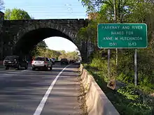
The Hutchinson River Parkway (known colloquially as The Hutch) is a north–south parkway in southern New York in the United States. It extends for 18.71 miles (30.11 km) from the massive Bruckner Interchange in the Throggs Neck section of the Bronx to the New York–Connecticut state line at Rye Brook. The parkway continues south from the Bruckner Interchange as the Whitestone Expressway (Interstate 678) and north into Greenwich, Connecticut, as the Merritt Parkway (Connecticut Route 15). The roadway is named for the Hutchinson River, a short 10 mile (16 km)-long stream in southern Westchester County that the road follows alongside. The river, in turn, was named for English colonial religious leader Anne Hutchinson.[3]
| ||||
|---|---|---|---|---|
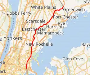
Hutchinson River Parkway highlighted in red | ||||
| Route information | ||||
| Maintained by NYCDOT and NYSDOT | ||||
| Length | 18.71 mi[1] (30.11 km) | |||
| Existed | 1928[2]–present | |||
| Restrictions | No commercial vehicles or drivers with learner's permits | |||
| Major junctions | ||||
| South end | ||||
| ||||
| North end | ||||
| Location | ||||
| Counties | Bronx, Westchester | |||
| Highway system | ||||
| ||||

Construction of the parkway began in 1924 and was completed in 1941. The section of the parkway between Eastern Boulevard (now Bruckner Boulevard) in the Bronx and U.S. Route 1 (US 1) in Pelham Manor was designated as New York State Route 1X (NY 1X) from 1941 to 1946. NY 1A was subsequently realigned to follow the Hutch between Eastern Boulevard and US 1. The NY 1A designation was removed around 1962.[4][5]
Route description
The road is designated as NY 908A within the Bronx and is maintained by the New York City Department of Transportation (NYCDOT). In Westchester County, the road is designated as NY 907W and is maintained by the New York State Department of Transportation (NYSDOT). Both designations are unsigned reference routes. Like the Bronx River Parkway, the reference route designation of the parkway in Westchester County violates the numbering scheme used by the NYSDOT.[6] The second digit of a reference route designation typically indicates its region. While other reference routes in the county carry a second digit of "8", as Westchester County is located in region 8, the "0" in 907W is indicative of regions 10 and 11, containing Long Island and New York City, respectively.[6][7]
Throggs Neck to Pelham
The Hutchinson River Parkway begins at the large Bruckner Interchange in the Throggs Neck section of the Bronx. This interchange consists of junctions with the Cross Bronx Expressway (I-95 and I-295), the Whitestone Expressway (I-678), and the Bruckner Expressway (I-95 and I-278). The Hutchinson River Parkway proceeds north as a continuation of I-678, entering exit 1, a small 1-lane ramp to Bruckner Boulevard near Saint Raymond's Cemetery. Just to the north of exit 1 gas stations appear on each side of the road, which turns northeast and into exit 2, a connection to East Tremont Avenue. After exit 2, the parkway crosses under the IRT Pelham Line just west of Middletown Road subway station, crossing into the Pelham Bay section of the Bronx.[8]
Just after crossing into Pelham Bay, the parkway enters exit 3E–W, an interchange with the Pelham Parkway in a small section of Pelham Bay Park. After crossing over Amtrak's Northeast Corridor, the parkway crosses out of Pelham Bay Park and into exit 4S–N, a junction with I-95 and the New England Thruway. Crossing over Bartow Avenue and the Hutchinson River, the parkway crosses into the main section of Pelham Bay Park, where exit 5 forks off towards the center of the park. The now six-lane parkway crosses north through Pelham Bay Park, entering exit 6, another junction with the New England Thruway. When the Hutchinson River Parkway leaves Pelham Bay Park, the right-of-way leaves the Bronx and enters Westchester County.[8] Now in the village of Pelham Manor, the parkway enters exit 7, an interchange with US 1 (Boston Post Road). Southbound, an exit 8 is present, a ramp to Sandford Boulevard in Pelham Manor. Proceeding northbound, exit 9 connects to Colonial Avenue, the continuation of Sandford Boulevard after the Hutchinson River Parkway in the adjacent village of Pelham. The parkway winds north through Pelham, entering exit 10 on the southbound lanes, a connection to East 3rd Street. Winding northeast, the parkway crosses under the Metro-North Railroad New Haven Line just west of Pelham station. Just after the line, the Hutchinson River Parkway crosses into exit 12, a bi-directional junction with Lincoln Avenue in Pelham.[8]
Mount Vernon to Connecticut
Soon the parkway leaves Pelham for Mount Vernon, entering the Chester Heights section. In Mount Vernon, the Hutchinson River Parkway enters exit 13, a connection to the Cross County Parkway. The parkway winds northeast into exit 14, a junction with New Rochelle Road, bending northwest through Nature Study Woods Park. The parkway then bends north into New Rochelle. Just after crossing into New Rochelle, the Cross County Parkway merges into the northbound lanes. Crossing through Twin Lakes Park, the parkway enters exit 16, a junction with the northern end of Webster Avenue. Passing around Reservoir 3, the Hutchinson River Parkway crosses into Eastchester and soon back into New Rochelle near exit 18, which connects to North Avenue.[8]
To the north, exit 18E and exit 18W going southbound junctions with Mill Road in Eastchester, the continuation of North Avenue. After exits 18E and 18W, the parkway passes east of Reservoir 1 and south of exit 19, Wilmot Road. The Hutchinson River Parkway proceeds northeast as a four-lane arterial through New Rochelle. The parkway crosses under NY 125 (Weaver Street), which is accessible southbound via exit 20. Proceeding northbound, exit 21 services Hutchinson Avenue, which connects to NY 125 and Quaker Ridge Country Club. Now in the Quaker Ridge section of Scarsdale, the Hutchinson River Parkway crosses into exit 22, Mamaroneck Avenue near Saxon Woods County Park. The parkway runs along the southern end of the park, entering exit 23S–N in the center of the park.[8]
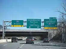
Exit 23S–N services another Mamaroneck Avenue as it crosses over the West Branch of the Mamaroneck River. Leaving the park, the Hutchinson River Parkway enters White Plains, crossing past a median rest area. The parkway continues northeast, entering exit 25, a diamond interchange with NY 127 (North Street) in Harrison. Passing Maple Moor Golf Course, the Hutchinson River Parkway enters exit 26E–W, a cloverleaf interchange with I-287 (the Cross Westchester Expressway). Just to the north of the interchange, I-684 forks to the northwest in Harrison. Just northeast of I-684, exit 27 forks to NY 120 (Purchase Street).[8]
After exit 27 the parkway makes a bend to the southeast entering exit 28, a junction with Lincoln Avenue in Harrison. The four-lane parkway winds northeast once again, entering exit 29, a junction with North Ridge Street in Rye Brook. The Hutchinson River Parkway enters exit 30S, a connection with NY 120A (King Street). Southbound, this interchange is designated exit 27S, a continuation of the numbering from the Merritt Parkway. At this interchange, the Hutchinson River Parkway crosses into the state of Connecticut and continues northeast as the Merritt Parkway (Route 15).[8]
History
Construction of the parkway began in 1924 and the first two-mile (3 km) section was completed in December 1927. By October 1928, 11 miles (18 km) of the parkway were open, connecting US 1 in Pelham Manor, New York with Westchester Avenue in White Plains, New York.[9] The original roadway was an undivided, limited-access parkway, designed with gently sloping curves, stone arch bridges, and wooden lightposts. The original 11-mile (18 km) section included bridle paths along the right-of-way. There was also a riding academy where the public could rent horses.[2]
In 1930, Robert Moses, an American public official who worked on New York metropolitan area infrastructure, announced plans to build more parkways in the Bronx.[10] A southward extension from Pelham Manor to Pelham Bay Park opened on December 11, 1937.[11][12][13] The new southerly extension became part of a rerouted New York State Route 1A.[14][15][16] The final segment of the parkway—a southward extension to the Bronx–Whitestone Bridge—was completed on October 11, 1941[17] and was initially designated NY 1X. The NY 1X designation was removed in 1946 and replaced with a realigned NY 1A,[18] which had previously followed Bruckner Boulevard and Shore Road between what is now the Bruckner Interchange and exit 5 on the Hutch.[19] The NY 1A designation was completely removed c. 1962.[20][21]
Originally, the parkway was built and designated all the way to the Bronx–Whitestone Bridge, but the original parkway designs did not allow for commercial traffic. When the bridge was designated I-678, the section between the Bruckner Interchange and the Bronx–Whitestone Bridge had to be converted to Interstate Highway standards. Once that was completed in 1972, that section was assigned the I-678 designation and renamed the Hutchinson River Expressway.[22][23][24] Modifications in 1984 included the straightening of some curves, increased sight distances, removal of the rustic lightposts, and lengthening of acceleration and deceleration lanes.[2] Originally, there was a 10 cent toll in Pelham between exits 7 and 8. The toll was increased to 25 cents in 1958[25] and removed on October 31, 1994, with the last toll collected just before midnight. The tolls were demolished on the Saw Mill River and Hutchinson River parkways in November 1994.[26]
Exit list
| County | Location | mi [1][27][28] | km | Exit | Destinations | Notes |
|---|---|---|---|---|---|---|
| The Bronx | Throggs Neck | 0.00 | 0.00 | 1S | Southern terminus; Bruckner Interchange | |
| 1 | I-95 / I-278 not signed northbound | |||||
| Schuylerville | 0.70 | 1.13 | 2 | East Tremont Avenue / Westchester Avenue | ||
| Pelham Bay | 1.93 | 3.11 | 3 | Signed as exits 3E (east) and 3W (west) | ||
| Baychester | 2.36 | 3.80 | 4S | Southbound exit and northbound entrance; exit 9 on I-95 | ||
| 4N | Southbound exit only; access via Baychester Avenue | |||||
| Hutchinson River | 2.90 | 4.67 | Hutchinson River Drawbridge | |||
| Pelham Bay Park | 3.35 | 5.39 | 5 | Orchard Beach, City Island | ||
| 4.20 | 6.76 | 6 | Northbound exit and southbound entrance; exit 14 on I-95 | |||
| Westchester | Pelham Manor | 4.54 | 7.31 | 7 | ||
| 5.20 | 8.37 | 8 | Sandford Boulevard – Mount Vernon, Pelham Manor | Southbound exit and entrance | ||
| Village of Pelham | 5.31 | 8.55 | 9 | Wolfs Lane – Mount Vernon, Pelham | Northbound exit and entrance | |
| 5.53 | 8.90 | 10 | East Third Street – Mount Vernon, Pelham | Southbound exit and northbound entrance; northbound entrance via Sparks Avenue | ||
| Pelham–Mount Vernon village/city line | 6.29 | 10.12 | 12 | East Lincoln Avenue – Mount Vernon, Pelham | ||
| 6.67 | 10.73 | 13 | Northbound exit and southbound entrance; exit 9 on C.C. Parkway; signed as Exit 15 southbound | |||
| 7.11 | 11.44 | 14 | Pelhamdale Avenue / New Rochelle Road – New Rochelle | |||
| Eastchester | 7.95 | 12.79 | 15 | Southbound exit and northbound entrance; eastern terminus of C.C. Parkway; signed as Exit 13 northbound | ||
| New Rochelle | 8.56 | 13.78 | 16 | Webster Avenue – New Rochelle | No southbound exit | |
| 8.94 | 14.39 | 17 | North Avenue – New Rochelle, Eastchester | Northbound exit and entrance | ||
| 9.30 | 14.97 | 18 | Mill Road – New Rochelle, Eastchester | Southbound exit and entrance; signed as exits 18E (east) and 18W (west) | ||
| 9.90 | 15.93 | 19 | Wilmot Road – New Rochelle | Southbound exit and northbound entrance | ||
| New Rochelle–Scarsdale city/village line | 11.10 | 17.86 | 20 21 | Signed as exit 20 southbound, exit 21 northbound; access via local roads | ||
| Scarsdale | 12.09 | 19.46 | 22 | Mamaroneck Road – Scarsdale, Mamaroneck | ||
| White Plains–Harrison city/village line | 13.05 | 21.00 | 23 | Mamaroneck Avenue – Mamaroneck, White Plains | Signed as exits 23S (south) and 23N (north) | |
| 14.57 | 23.45 | 25 | ||||
| Harrison | 15.69 | 25.25 | 26 | Cloverleaf interchange with Westchester Avenue; signed as exits 26E (east) and 26W (west) | ||
| 16.01 | 25.77 | 26N | Northbound exit and southbound entrance; access via unsigned NY 984J | |||
| 16.41 | 26.41 | 27 | ||||
| 17.23 | 27.73 | 28 | Lincoln Avenue – Harrison, Rye Brook | |||
| Rye Brook | 17.96 | 28.90 | 29 | North Ridge Street – Rye Brook | ||
| 18.70 | 30.09 | 30S 27S | Signed as exit 30S northbound, exit 27S southbound; access to NY 120A north via Merritt Parkway exit 27 | |||
| 18.71 | 30.11 | 27N | Continuation into Connecticut | |||
| 1.000 mi = 1.609 km; 1.000 km = 0.621 mi | ||||||
See also
References
- "2014 Traffic Data Report for New York State" (PDF). New York State Department of Transportation. July 22, 2015. Retrieved January 14, 2020.
- "Hutchinson River Parkway Highlights". New York City Department of Parks and Recreation. Retrieved November 18, 2008.
- https://www.womenofthehall.org/inductee/anne-hutchinson/
- New York and Metropolitan New York (Map) (1961-62 ed.). Cartography by H.M. Gousha Company. Sunoco. 1961.
- New York with Sight-Seeing Guide (Map). Cartography by General Drafting. Esso. 1962.
- "Bridge Inventory Manual – Appendix G: State Touring Route Numbers for Named Roads" (PDF). New York State Department of Transportation. April 2005. Archived from the original (PDF) on March 4, 2016. Retrieved April 1, 2010.
- "NYDOT Ref Marking" (PDF). Dot.ny.gov. New York Department of Transportation. Retrieved March 4, 2019.
- Microsoft; Nokia (October 7, 2012). "overview map of Hutchinson River Parkway" (Map). Bing Maps. Microsoft. Retrieved October 7, 2012.
- Times, Special To The New York (October 21, 1928). "HUTCHINSON PARKWAY TO OPEN ON SATURDAY; Eleven-Mile Highway Will Be an Express Traffic Route Through Westchester". The New York Times. ISSN 0362-4331. Archived from the original on August 6, 2017. Retrieved August 6, 2017.
- Gallery, University of Rochester Memorial Art; Searl, Marjorie B. (2006). Seeing America: Painting and Sculpture from the Collection of the Memorial Art Gallery of the University of Rochester. University Rochester Press. p. 212. ISBN 978-1-58046-246-4. Archived from the original on July 31, 2018. Retrieved March 11, 2018.
- "NEW BRONX TRAFFIC LINK; Hutchinson River Parkway Extension Opens Today". The New York Times. December 11, 1937. ISSN 0362-4331. Archived from the original on March 12, 2018. Retrieved March 11, 2018.
- Panetta, Roger G. (2006). Westchester: The American Suburb. Fordham Univ Press. p. 53. ISBN 978-0-8232-2594-1. Archived from the original on July 31, 2018. Retrieved March 11, 2018.
- "New York City Department of Parks Press Releases, January-December 1937". kermitproject.org. Archived from the original on March 12, 2018. Retrieved March 11, 2018.
- Thibodeau, William A. (1938). The ALA Green Book (1938–39 ed.). Automobile Legal Association.
- New York Info-Map (Map). Cartography by Rand McNally and Company. Gulf Oil Company. 1940.
- New York (Map). Cartography by General Drafting. Esso. 1940.
- "New York City Department of Parks Press Releases, July-December 1941". kermitproject.org. Archived from the original on March 12, 2018. Retrieved March 11, 2018.
- Official Highway Map of New York State (Map) (1947–48 ed.). Cartography by General Drafting. State of New York Department of Public Works.
- New York with Pictorial Guide (Map). Cartography by General Drafting. Esso. 1942.
- New York and Metropolitan New York (Map) (1961–62 ed.). Cartography by H.M. Gousha Company. Sunoco. 1961.
- New York with Sight-Seeing Guide (Map). Cartography by General Drafting. Esso. 1962.
- New York and Metropolitan New York (Map). Cartography by Rand McNally and Company. Sinclair Oil Corporation. 1962.
- New York Happy Motoring Guide (Map) (1963 ed.). Cartography by General Drafting. Esso. 1963.
- Public Papers . State Printers. 1972. Archived from the original on July 31, 2018. Retrieved March 12, 2018.
- Steinberg, Jacques (June 8, 1994). "Albany Leaders Strike Deal to End 25¦-Tolls on Hutchinson and Saw Mill River Parkways". The New York Times. Archived from the original on March 12, 2018. Retrieved March 11, 2018.
- "Tolls Abolished and Smiley Face Exits the Saw Mill Parkway". The New York Times. November 13, 1994. p. WC2.
- "Bronx County Inventory Listing" (CSV). New York State Department of Transportation. August 7, 2015. Retrieved September 5, 2017.
- "Westchester County Inventory Listing" (CSV). New York State Department of Transportation. August 7, 2015. Retrieved September 5, 2017.
- Google (January 14, 2020). "Hutchinson River Parkway" (Map). Google Maps. Google. Retrieved January 14, 2020.
External links
| Wikimedia Commons has media related to Hutchinson River Parkway. |
- Hutchinson River Parkway at Alps' Roads