Ilanz/Glion
Ilanz/Glion is a municipality in the Surselva Region in the Swiss canton of Graubünden. On 1 January 2014 the former municipalities of Castrisch, Ilanz, Ladir, Luven, Pitasch, Riein, Ruschein, Schnaus, Sevgein, Duvin, Pigniu, Rueun and Siat merged into the new municipality of Ilanz/Glion.[3]
Ilanz/Glion | |
|---|---|
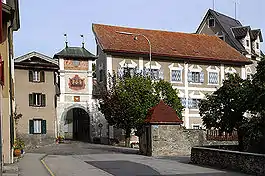 | |
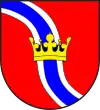 Coat of arms | |
Location of Ilanz/Glion 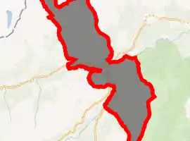
| |
 Ilanz/Glion Ilanz/Glion | |
| Coordinates: 46°46′N 9°12′E | |
| Country | Switzerland |
| Canton | Graubünden |
| District | Surselva |
| Government | |
| • Mayor | Gemeindepräsident/President (list) Aurelio Casanova (as of 2016) |
| Area | |
| • Total | 133.48 km2 (51.54 sq mi) |
| Population (2018-12-31)[2] | |
| • Total | 4,753 |
| • Density | 36/km2 (92/sq mi) |
| Time zone | UTC+01:00 (Central European Time) |
| • Summer (DST) | UTC+02:00 (Central European Summer Time) |
| Postal code(s) | 7130 |
| SFOS number | 3619 |
| Localities | Ilanz/Glion, Strada, Castrisch, Ladir, Luven, Pitasch, Riein, Ruschein, Schnaus, Sevgein, Duvin, Pigniu, Rueun and Siat |
| Surrounded by | Schluein, Sagogn, Safiental, Vals, Lumnezia, Obersaxen Mundaun, Waltensburg/Vuorz, Andiast, Glarus Süd (GL) |
| Website | www SFSO statistics |
History
Castrisch is first mentioned in 765 as Castrices.[4] Ladir is first mentioned about 850 as Leitura.[5] Luven is first mentioned in 765 as Lobene.[6] Pitasch is first mentioned about 801–50 as Pictaui though this comes from a 16th-century copy of the lost original. In 960 it was mentioned as in Pictaso.[7] Riein is first mentioned in 765 as Renino. In 960 it was mentioned as Raine.[8] Ruschein is first mentioned in 765 as Rucene.[9] Schnaus is first mentioned about 840 as Scanaues.[10] Sevgein is first mentioned about 840 as Soviene.[11] Duvin is first mentioned about 840 as Auna. In 1290 it was mentioned as Aiuns[12] Rueun is first mentioned in 765 as Ruane. Until 1943 Rueun was known as Ruis.[13] Siat is first mentioned about 840 as Septe. Until 1943 Siat was known as Seth.[14]
Ilanz
Ilanz is first mentioned in 765 as Iliande.[15] Ilanz became the capital of the newly formed Grey League in 1395. The Grey League was the second of Three Leagues which eventually formed canton Graubünden. Johannes von Ilanz, the Abbott of Disentis, was among the three nobles instrumental in creating this ""eternal alliance.""
Ilanz has a special place in the history of the Protestant Reformation. In the 1520s, the Diet of Ilanz declared that citizens of the Three Leagues should be free to choose between Catholicism and the Protestant forms of Christianity rising to the fore. The so-called “Ilanz Reformation” of 1526 resulted in another systematic shock to the Catholic Church which had been under philosophical attack since Zurich in 1523 when Protestantism first rose to primacy in a major population center. These and other events resulted in a counter-reformation within the Swiss Confederation that reversed many of the gains of the Reformation in Switzerland.[16]
Pigniu
Pigniu was probably settled from Andiast. The name Pingyow first appears in 1403. The German name Panix is first mentioned in 1522. Until 1984 Pigniu was known as Pigniu/Panix.
The Church of St. Valentin was dedicated in 1465 and was a popular goal of pilgrimages. Until 1667, Pigniu had its own parish.
On 7 October 1799, the Russian Army under command of Field Marshal Suvorov crossed the Pigniu pass.[17]
Geography
The former municipalities that now make up Ilanz/Glion have a total combined area of 133.48 km2 (51.54 sq mi).[18]
Demographics
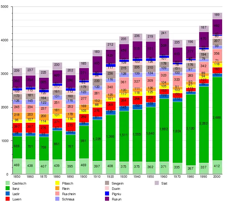
The total population of Ilanz/Glion (as of December 2019) is 4,757.[19]
The historical population is given in the following chart:[20]
Weather
Ilanz has an average of 112.6 days of rain per year and on average receives 952 mm (37.5 in) of precipitation. The wettest month is August during which time Ilanz receives an average of 102 mm (4.0 in) of precipitation. During this month there is precipitation for an average of 11.4 days. The month with the most days of precipitation is June, with an average of 11.5, but with only 93 mm (3.7 in) of precipitation. The driest month of the year is October with an average of 63 mm (2.5 in) of precipitation over 11.4 days.[21]
Pigniu has an average of 166.3 days of rain or snow per year and on average receives 1,347 mm (53.0 in) of precipitation. The wettest month is August during which time Pigniu receives an average of 141 mm (5.6 in) of rain or snow. During this month there is precipitation for an average of 16 days. The month with the most days of precipitation is May, with an average of 16.6, but with only 124 mm (4.9 in) of rain or snow. The driest month of the year is October with an average of 90 mm (3.5 in) of precipitation over 16 days.[22]
Sights
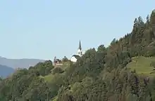
The village Church of St. Zeno in Ladir was first mentioned in 998. The choir wall paintings are worth seeing. Additionally, the municipality has an excellent view of the surrounding mountains and valleys. The ruins of Grüneck Castle (Ruine Grüneck), destroyed before 1544, are visible today in Ilanz village.
Heritage sites of national significance
The Church of S. Margreta and the Church of S. Martin in Ilanz along with the Swiss Reformed Church building in Pitasch are listed as Swiss heritage sites of national significance.[23]
The Reformed Church in Pitasch was built in the mid-12th century into its current form. The church floorplan is a single nave church with a single half-round apse. The interior murals date to about 1420, and on the exterior south wall is a mural of St. Martin and St. Christopher from the studio of the unknown Waltensburg Master which was painted about 1340.[24]
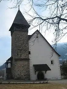 Church of S. Martin
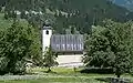 Exterior of the Church in Pitasch
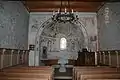 Interior of the church in Pitasch
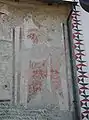 St. Christopher (Christoforus) in Pitasch
Other sites
The ruins of Grüneck Castle (Ruine Grüneck), destroyed before 1544, are visible today. A Carolingian hoard of two ornately decorated salt containers and coins was discovered near the ruins of the castle in 1811. One of the containers, which is made from antler and T-shaped, is now kept in the British Museum.[25] A hoard of forty Carolingian gold coins, including nine denier,[26] known as the Ilanz Hoard was discovered near the castle in 1904. In addition to the Carolingian coins, the horde contained Lombard and arab coins. About 142 coins from discoveries near the castle are kept at the Rätisches Museum in Chur.[27]
Transportation
The municipality has three railway stations: Castrisch, Ilanz, and Rueun. All three are located on the Reichenau-Tamins–Disentis/Mustér line with regular service to Disentis/Mustér and Scuol-Tarasp.
References
- "Arealstatistik Standard - Gemeinden nach 4 Hauptbereichen". Federal Statistical Office. Retrieved 13 January 2019.
- "Ständige Wohnbevölkerung nach Staatsangehörigkeitskategorie Geschlecht und Gemeinde; Provisorische Jahresergebnisse; 2018". Federal Statistical Office. 9 April 2019. Retrieved 11 April 2019.
- Nomenklaturen – Amtliches Gemeindeverzeichnis der Schweiz (in German) accessed 13 December 2014
- Castrisch in German, French and Italian in the online Historical Dictionary of Switzerland.
- Ladir in German, French and Italian in the online Historical Dictionary of Switzerland.
- Luven in German, French and Italian in the online Historical Dictionary of Switzerland.
- Pitasch in German, French and Italian in the online Historical Dictionary of Switzerland.
- Riein in German, French and Italian in the online Historical Dictionary of Switzerland.
- Ruschein in German, French and Italian in the online Historical Dictionary of Switzerland.
- Schnaus in German, French and Italian in the online Historical Dictionary of Switzerland.
- Sevgein in German, French and Italian in the online Historical Dictionary of Switzerland.
- Duvin in German, French and Italian in the online Historical Dictionary of Switzerland.
- Rueun in German, French and Italian in the online Historical Dictionary of Switzerland.
- Siat in German, French and Italian in the online Historical Dictionary of Switzerland.
- Ilanz in German, French and Italian in the online Historical Dictionary of Switzerland.
- Durant, Will, The Reformation, A History of European Civilization from Wyclif to Calvin: 1300-1564, New York: Simon & Schuster, 1957, 403-414.
- Pigniu in German, French and Italian in the online Historical Dictionary of Switzerland.
- Arealstatistik Standard - Gemeindedaten nach 4 Hauptbereichen
- "Ständige und nichtständige Wohnbevölkerung nach institutionellen Gliederungen, Geburtsort und Staatsangehörigkeit". bfs.admin.ch (in German). Swiss Federal Statistical Office - STAT-TAB. 31 December 2019. Retrieved 6 October 2020.
- Federal Statistical Office STAT-TAB Bevölkerungsentwicklung nach Region, 1850-2000 Archived 2012-03-17 at the Wayback Machine (in German) accessed 29 January 2011
- "Temperature and Precipitation Average Values-Table, 1961-1990" (in German, French, and Italian). Federal Office of Meteorology and Climatology - MeteoSwiss. Archived from the original on 27 June 2009. Retrieved 8 May 2009., the weather station elevation is 705 meters above sea level.
- "Temperature and Precipitation Average Values-Table, 1961-1990" (in German, French, and Italian). Federal Office of Meteorology and Climatology - MeteoSwiss. Archived from the original on 27 June 2009. Retrieved 8 May 2009., the weather station elevation is 1325 meters above sea level.
- Swiss inventory of cultural property of national and regional significance Archived 2009-05-01 at the Wayback Machine 21.11.2008 version, (in German) accessed 10-Nov-2009
- Flüeler (1982). Kulturführer Schweiz. Zurich, CH: Ex Libris Verlag AG. p. 281.
- British Museum Collection
- Ernesto Bernareggi (1983). Carolingian Gold Coins from the Ilanz Hoard. Studies in Numismatic Method: Presented to Philip Grierson. Editor: C. N. L. Brooke. CUP Archive. pp. 127–136. ISBN 9780521225038.
- "Collection of the Rätisches Museum". www.gr.ch. Retrieved 6 October 2020.
External links
| Wikimedia Commons has media related to Ilanz/Glion. |
- Castrisch in German, French and Italian in the online Historical Dictionary of Switzerland.
- Ilanz in German, French and Italian in the online Historical Dictionary of Switzerland.
- Ladir in German, French and Italian in the online Historical Dictionary of Switzerland.
- Luven in German, French and Italian in the online Historical Dictionary of Switzerland.
- Pitasch in German, French and Italian in the online Historical Dictionary of Switzerland.
- Riein in German, French and Italian in the online Historical Dictionary of Switzerland.
- Ruschein in German, French and Italian in the online Historical Dictionary of Switzerland.
- Schnaus in German, French and Italian in the online Historical Dictionary of Switzerland.
- Sevgein in German, French and Italian in the online Historical Dictionary of Switzerland.
- Duvin in German, French and Italian in the online Historical Dictionary of Switzerland.
- Pigniu in German, French and Italian in the online Historical Dictionary of Switzerland.
- Rueun in German, French and Italian in the online Historical Dictionary of Switzerland.
- Siat in German, French and Italian in the online Historical Dictionary of Switzerland.
Municipalities in the Surselva Region, Switzerland | ||
|---|---|---|