Illinois Route 48
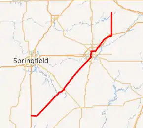
Illinois Route 48 (IL 48) is an 85.38-mile-long (137.41 km) north–south[3] state highway with its southern terminus at Interstate 55 (I-55) and IL 127 in Raymond and its northern terminus at IL 54 east of Clinton.
| ||||
|---|---|---|---|---|

IL 48 highlighted in red | ||||
| Route information | ||||
| Maintained by IDOT | ||||
| Length | 85.38 mi[1] (137.41 km) | |||
| Existed | 1924[2]–present | |||
| Major junctions | ||||
| South end | ||||
| North end | ||||
| Location | ||||
| Counties | Montgomery, Christian, Macon, Piatt, DeWitt | |||
| Highway system | ||||
| ||||
Route description
IL 48 travels southwest to northeast from I-55 to east of Clinton. It is an undivided surface street for its entire length. It also serves the cities of Raymond, Harvel, Taylorville, and Decatur.
History
SBI Route 48 traveled from Onarga to Raymond via the current IL 48 and IL 54. The portion from DeWitt to Onarga became U.S. Route 54 (US 54) in 1942, but in 1972 US 54 was pulled back to its current terminus in Pittsfield, and IL 54 was implemented from Springfield to Onarga.
Major intersections
| County | Location | mi[4] | km | Destinations | Notes |
|---|---|---|---|---|---|
| Montgomery | | Continuation beyond IL 48 to Historic US 66 | |||
| 0.0 | 0.0 | Southern terminus; south end of IL 127 concurrency; I-55 exit 63 | |||
| Raymond | 3.5 | 5.6 | North end of IL 127 concurrency | ||
| Christian | Taylorville | 26.7 | 43.0 | ||
| Macon | | 49.0 | 78.9 | Interchange | |
| Decatur | 51.4 | 82.7 | Western terminus of IL 105 | ||
| 53.0 | 85.3 | ||||
| 55.1 | 88.7 | South end of IL 121 concurrency | |||
| 56.0 | 90.1 | ||||
| 57.7 | 92.9 | North end of IL 121 concurrency | |||
| | 60.5 | 97.4 | I-72 exit 144 | ||
| Macon–Piatt county line | | 71.6 | 115.2 | Northern terminus of IL 32 | |
| | 72.0 | 115.9 | I-72 exit 156 | ||
| De Witt | Weldon | 79.7 | 128.3 | ||
| | 85.38 | 137.41 | Northern terminus | ||
1.000 mi = 1.609 km; 1.000 km = 0.621 mi
| |||||
See also
 U.S. Roads portal
 Illinois portal
References
- Illinois Technology Transfer Center (2006). "T2 GIS Data". Retrieved 2007-11-08.
- Carlson, Rich (March 15, 2005). "Illinois Highways Page: Routes 41 thru 60". Retrieved April 7, 2006.
- "Route 48". Illinois Highways Ends. Archived from the original on October 5, 2012. Retrieved April 7, 2006.
- Google Maps,
This article is issued from Wikipedia. The text is licensed under Creative Commons - Attribution - Sharealike. Additional terms may apply for the media files.
