Indian Rocks Causeway
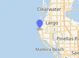
The Indian Rocks Causeway (also called the Indian Rocks Bridge) is a twin-span double-leaf bascule bridge that crosses the Narrows, part of the Gulf Intracoastal Waterway, connecting the barrier islands of Indian Rocks Beach and the mainland of Seminole, Florida. The bridge carries Walsingham Road, part of SR 688. The eastbound span of the Indian Rocks Causeway was built in 1958, replacing the original swing bridge built in 1916, and the westbound span was built in 1999.[1][2][3]
Indian Rocks Causeway | |
|---|---|
 The Indian Rocks Causeway in 2019. | |
| Coordinates | 27°53′00.1″N 82°50′43.6″W |
| Carries | |
| Crosses | The Narrows |
| Locale | Indian Rocks Beach, Florida |
| Official name | Indian Rocks Causeway |
| Other name(s) | Indian Rocks Bridge |
| Owner | State Highway Agency |
| Characteristics | |
| Design | Bascule |
| Material | Steel |
| Total length | 458 feet |
| Width | 35 feet |
| Clearance above | 19 feet |
| Clearance below | 23 feet |
| No. of lanes | Four |
| History | |
| Opened | 1916 (original swing bridge) 1958 (current eastbound) 1999 (current westbound) |
| Statistics | |
| Daily traffic | 8,550 |
| Toll | None |
| Location | |

| |
References
- "BridgeReports.com | SR 688 WALSINGHAM over INTRACOASTAL WATERWAY, Pinellas County, Florida". bridgereports.com. Retrieved 2020-10-17.
- "Florida Route 688 Bascule Bridge". Bridgehunter.com. Retrieved 2020-10-17.
- "Indian Rocks Causeway Bridge". drawbridgeahead.com. Retrieved 2020-10-17.
See also
- Dunedin Causeway
- Clearwater Memorial Causeway
- Sand Key Bridge
- Belleair Causeway
- Park Boulevard Bridge
- Tom Stuart Causeway
- John's Pass Bridge
- Treasure Island Causeway
- Corey Causeway
- Pinellas Bayway
This article is issued from Wikipedia. The text is licensed under Creative Commons - Attribution - Sharealike. Additional terms may apply for the media files.