Isle de Jean Charles, Louisiana
Isle de Jean Charles (known locally in Louisiana French as Isle à Jean Charles) is a narrow ridge of land situated in Terrebonne Parish, Louisiana. For over 170 years, it has been the historical homeland and burial ground of the state-recognized tribe of the Isle de Jean Charles Band of Biloxi-Chitimacha-Choctaw Indians.[1] Residents of the Island have long been threatened by Louisiana's coastal erosion, as coastal Louisiana loses a landmass the size of Manhattan every year.[2] In 1955, Isle de Jean Charles consisted of over 22,000 acres (8,900 ha) and has since lost about 98% of its land due to saltwater intrusion, and subsidence.[3][4][5][6] In January 2016, the state of Louisiana received substantial funding from the United States Department of Housing and Urban Development to fund the tribe's resettlement to safer ground.[7]
Isle de Jean Charles | |
|---|---|
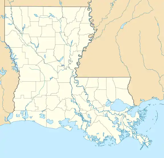 Isle de Jean Charles Location of Isle de Jean Charles in Louisiana  Isle de Jean Charles Isle de Jean Charles (the United States) | |
| Coordinates: 29°23′15″N 90°28′59″W | |
| Country | United States |
| State | Louisiana |
| Parish | Terrebonne |
| Elevation | 2 ft (0.6 m) |
| Population (2019) | |
| • Total | 26 |
| Time zone | UTC-6 (CST) |
| • Summer (DST) | UTC-5 (CDT) |
| Area code(s) | 985 |
Background
In the 1830s, the Biloxi-Chitimacha-Choctaw tribe's ancestors moved to Isle de Jean Charles to escape the Indian Removal Act and the Trail of Tears.[8] By 1910, the island had grown from 16 to 77 families.[9] The population of Jean Charles sustained themselves through fishing, oyster farming, trapping and subsistence farming. In the 1930s, a missionary grade school on the mainland was built for the nearby indigenous peoples. In 1959, Daigleville Indian High School in Houma, 25 miles (40 km) inland from the Isle de Jean Charles, became the first Indigenous high school in Louisiana.[10] Until 1953, when the road that connects the island to the mainland was built, the tribe could commute to and from the inland only by boat. Due to the road's traveling through open waters, it was extremely susceptible to flooding and erosion, and frequently became uncrossable. In the 1940s, companies began offshore oil drilling projects and dredging near the island, activities which contributed to the erosion of the island and its island road.[11]
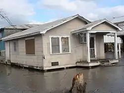
The Isle de Jean Charles was over 5 miles wide and 11 miles long, but today it has shrunk to 1/4 mile wide and 2 miles long.[9] The causes of land loss have been both natural and man-made. Hurricanes, such as Katrina in 2005, flooded the area with salt water, ruining homes and causing land subsidence. Rising sea levels have also contributed to land loss. Man made disturbances such as dams and levees as well as the dredging of canals for shipping and oil pipelines all eroded the marshland to almost bare nothingness.[12]
These disturbances have decreased the plant and animal biodiversity in the marshland, negatively impacting the tribe's quality of life. As a result, most of the Biloxi-Chitimacha-Choctaw members who could afford to move off the island have done so. The dispersal of their tribal community disrupted their customs, traditions, and culture.[13] Recent coastal restoration efforts have not been able to salvage the island. The Army Corps of Engineers left the Isle de Jean Charles out of levee projects, making the land even more vulnerable to natural disasters than the other surrounding areas.[10] In the early 2000s, only 25 families remained on the island, and the Biloxi-Chitimacha-Choctaw's Chief Albert Naquin began tireless efforts to relocate the entire community to save the tribe's culture and traditions. In 2016, over a decade later, the tribe was finally rewarded with a partial victory.
Before the Biloxi-Chitimacha-Choctaw's tribe's victory, an award-winning documentary, Can't Stop The Water, was filmed in 2013 about the community's on-going environmental hardships.[14]
Community resettlement efforts

Due to lack of government support for flood mitigation and land restoration, the Isle de Jean Charles Tribal Council decided they needed action and assistance for relocation of their whole community. Traditional Chief Albert Naquin and the Tribal Council have recently seen significant progress towards community resettlement after their 16-year battle of working within the community developing plans, building partnerships, and conducting outreach in order to relocate to higher, safer ground inland.[15] While progress has been made, there have also been multiple setbacks which stalled their momentum.
In 2002, the US Army Corps of Engineers worked with the leadership of the Tribe to identify a nearby site where the community could rebuild.. The USACE hired architects for the relocation proposal, with the idea of maintaining a cohesive community to be consistent with the tribe's federal recognition process.. But when it came time to vote, the majority of people from Isle de Jean Charles did not want to relocate due to their culture's close ties to the land. Some residents felt the government wanted residents to relocate so the oil industry could have free range over the area without political conflict. Conflicts over property and land with the tribe, multinational oil and gas corporations and land developers, had been an ongoing process. The land was a part of their culture and life style. The Biloxi-Chitimacha-Choctaw people wanted to move as an entire community so as to keep their traditions and culture together and alive.[16]
The USACE stated that if the community could find an appropriate property to relocate to, they would grant them funding and reconsider including the community in the hurricane protection system. However, the Louisiana government did not consider the social, psychological, and financial costs associated with moving fishing families inland. The tribe would encounter a great loss of local knowledge and a gain of mental stress of being constantly fighting for their land and traditional lifestyle.
Since 2010, the Isle de Jean Charles Tribe has been working with longtime partners at The Lowlander Center and a team of experts in hazard mitigation, climate adaptation, community planning, architecture, and other relevant fields, to develop their own plan for resettlement. Finally, on January 25, 2016, the State of Louisiana received $48 million from the Department of Housing and Urban Development to put towards the Isle de Jean Charles resettlement, as part of the National Disaster Resilience Competition (NDRC).[17][18] The Isle de Jean Charles Resettlement Project was adopted by the state, giving the community renewed hope that their 16-year commitment to resettlement was finally underway.[19][20]
Oil and gas production in Terrebonne Parish
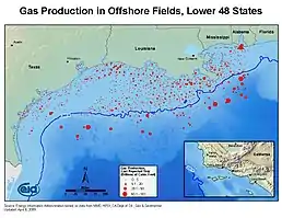
Louisiana's Terrebonne Parish has been a prime location for oil extraction and production.[21] Oil and gas production corporations largely influence the coastal communities of Southern Louisiana, with around 90% of land in Terrebonne Parish belonging to non-local manufacturing companies.[22] The Isle de Jean Charles is entrenched in numerous oil fields that are still utilized by oil manufactures.[23] Construction and development of oil-rigs and pipelines continue to disrupt the geography of the wetlands.[24]
Discovery of oil
In the late 1920s, the Texas-based oil corporation Texaco began exploring the bayous and marshlands of Louisiana in search of oil. Land leases were negotiated between Texaco (and other oil extraction enterprises), the Louisiana Land & Exploration Company, and the state of Louisiana. Oil was first discovered in Terrebonne Parish in 1929. Texaco and other groups quickly monopolized the land in the area.[22]
Production levels
Oil and natural gas extraction and production rapidly expanded in Terrebonne Parish, reaching an all-time high in the 1960s and 1970s. Peak production reached 31,520,394 Barrel units of oil and 550,018,432 million cubic feet of gas in 1977. The OPEC Embargo of 1973 and 1974 influenced this boom, as domestic sources of oil production were particularly desirable and valuable. Oil and gas production levels have steadily fallen since their peak in the late 1970s. In 2014, 3,260,362 Barrel units of oil and 31,100,655 million cubic feet of gas were produced in Terrebonne Parish.[21]
Environmental impact
In order to facilitate the extraction and transportation of oil and natural gas, the Houma Navigation Canal was built. This man-made waterway connected Terrebonne Parish's largest and only city, Houma, to the Gulf of Mexico and was completed in 1962. It has been thought to have directly contributed to the degradation of the wetlands of southern Louisiana, especially those in Terrebonne Parish. Higher levels of water salinity from the adjacent bay and the increase of artificial waterways, pipelines, and smaller navigation canals have exacerbated the degradation of the wetlands east of the Houma Navigation Canal, where the Isle de Jean Charles is located.[25]
In popular culture
- Director Benh Zeitlin of Beasts of the Southern Wild (2012) said in interviews that Isle de Jean Charles was the geographic inspiration for the setting of "The Bathtub," the fictional island portrayed in his film.
- Cottage Films filmed tribal life for years on Isle de Jean Charles for a documentary film called Can't Stop The Water (2013), directed by Rebecca and Jason Ferris.[26]
References
- Isle de Jean Charles Band of Biloxi-Chitimacha-Choctaw Indians, official website
- Rich, Nathaniel (2014-10-03). "The Most Ambitious Environmental Lawsuit Ever". The New York Times. ISSN 0362-4331. Retrieved 2017-04-14.
- Thomas, David et al., 2016. The Dictionary of Physical Geography, Fourth Edition, Wiley Blackwell, p. 471
- Isle de Jean Charles Band of Biloxi-Chitimacha-Choctaw Indians Resettlement Project, resettlement project website
- Wolstencroft, M.; Shen, Zh.; Törnqvist, T.; Milne, G.; Kulp, M.; 2014. Understanding subsidence in the Mississippi Delta region due to sediment, ice, and ocean loading. Insight from geophysical modelling" [in:] Journal of Geophysical Research: Solid Earth, 119, 3838-3856, 31 March 2014; published online: 28 APR 2014, http://www.tulane.edu/~tor/documents/JGR2014.pdf
- Törnqvist, T.; Wallace, D.; Storms J.; Wallinga, J.; van Dam, R.; Blaauw, M.; Derksen, M.;, Klerks, C.; Meijneken, C.; Snijders, E., 2008. Mississippi Delta subsidence primarily caused by compaction of Holocene strata, [in:] Nature Geoscience 1, 173 - 176 (2008), Published online: 17 February 2008 | doi:10.1038/ngeo129 http://www.nature.com/ngeo/journal/v1/n3/full/ngeo129.html
- Davenport, Coral; Robertson, Campbell (2016-05-02). "Resettling the First American 'Climate Refugees'". The New York Times. ISSN 0362-4331. Retrieved 2017-04-14.
- Sutter, John D. "Each hour, a football field of land vanishes". CNN. Photographs by William Widmer/Redux. Retrieved 2017-04-14.
- "The Island". Can't Stop The Water. Retrieved 2017-03-01.
- "The Island". Isle de Jean Charles, Louisiana. Retrieved 2017-03-01.
- "Oil and Gas fields in Louisiana - WorldMap". worldmap.harvard.edu. Retrieved 2017-03-18.
- "The Environment". Isle de Jean Charles, Louisiana. Retrieved 2017-03-01.
- "The First Official Climate Refugees in the U.S. Race Against Time". National Geographic News. 2017-05-25. Retrieved 2017-03-18.
- D'Angelo, Chris (2016-02-12). "A Louisiana Tribe Is Now Officially A Community Of Climate Refugees". Huffington Post. Retrieved 2017-04-14.
- "ABOUT THE PROJECT". www.coastalresettlement.org. Retrieved 2017-04-23.
- Jarvie, Jenny (April 23, 2019). "On a sinking Louisiana island, many aren't ready to leave". Los Angeles Times. Retrieved 2019-04-24.
- "Home". Isle de Jean Charles, Louisiana. Retrieved 2017-04-23.
- https://www.nytimes.com/2016/05/03/us/resettling-the-first-american-climate-refugees.html
- "Isle De Jean Charles Community to Receive $52 Million to Relocate." HoumaToday.com. HoumaToday, 21 Jan. 2016. Web. 22 Jan. 2016.
- Baurick, Tristan. "Deadline set for residents of vanishing Isle de Jean Charles to apply for relocation". NOLA.com. Retrieved 2021-01-25.
- "Terrebonne Parish, LA Oil and Gas Permits, Production, Wells, and Operators". www.drillingedge.com. Retrieved 2017-03-18.
- L. Sell, James; McGuire, Tom (2008). "History of the Offshore Oil and Gas Industry in Southern Louisiana, Volume IV: Terrebonne Parish" (PDF). U.S. Department of the Interior Study. U.S. Department of the Interior, Minerals Management Service: 44–45.
- "Oil and Gas fields in Louisiana - WorldMap". worldmap.harvard.edu. Retrieved 2017-03-19.
- "The Island". Can't Stop The Water. Retrieved 2017-03-19.
- Steyer, Gregory D. (2008). "Influence of the Houma Navigation Canal on Salinity Patterns and Landscape Configuration in Coastal Louisiana" (PDF). U.S. Geological Survey Open-File Report 2008-1127: 133–138 – via U.S Geological Survey Database.
- Isle de Jean Charles Biloxi-Chitimacha-Choctaw
External links
- Isle de Jean Charles band of Biloxi-Chitimacha-Choctaw
- Official Isle de Jean Charles Resettlement Project
- Isle de Jean Charles Resettlement Project
- Barry, Dan (June 19, 2006). In Louisiana, a Sinking Island Wars With Water and the Government. New York Times
- Isle de Jean Charles, LA via New Deal Network Photo Gallery
- "Last Stand on the Island", a short film about the inhabitants of Isle de Jean Charles
- "Vanishing Island", NYTimes short film
- Video.NationalGeographic.com Staying Afloat On A Drowning Island
- Can't Stop the Water documentary