Istres
Istres (French pronunciation: [istʁ]) (Occitan: Istre) is a commune in southern France, some 60 km (38 mi) northwest of Marseille. It is in the Provence-Alpes-Côte d'Azur region, in the Bouches-du-Rhône department, of which it is a subprefecture.
Istres | |
|---|---|
Subprefecture and commune | |
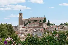 Historic center | |
 Coat of arms | |
Location of Istres 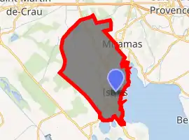
| |
 Istres  Istres | |
| Coordinates: 43°30′54″N 4°59′22″E | |
| Country | France |
| Region | Provence-Alpes-Côte d'Azur |
| Department | Bouches-du-Rhône |
| Arrondissement | Istres |
| Canton | Istres |
| Intercommunality | Aix-Marseille-Provence |
| Government | |
| • Mayor (2020–2026) | François Bernardini[1] |
| Area 1 | 113.73 km2 (43.91 sq mi) |
| Population (2017-01-01)[2] | 43,133 |
| • Density | 380/km2 (980/sq mi) |
| Time zone | UTC+01:00 (CET) |
| • Summer (DST) | UTC+02:00 (CEST) |
| INSEE/Postal code | 13047 /13800 |
| Elevation | 0–120 m (0–394 ft) (avg. 20 m or 66 ft) |
| 1 French Land Register data, which excludes lakes, ponds, glaciers > 1 km2 (0.386 sq mi or 247 acres) and river estuaries. | |
Location
Istres is adjacent to the Étang de Berre lagoon (the largest in Europe) and the Étang de l'Olivier lagoon. It is located some 60 km (38 mi) north-west of Marseille, 20 km (13 mi) south-west of Salon-de-Provence, 10 km (6 mi) north of Martigues and 45 km (28 mi) south-east of Arles. Istres is also adjacent to the plaine de la Crau and the Camargue national park.
Sports
The city has numerous sports facilities and exactly 102 clubs. Each year, a race is organized around the Étang de l'Olivier. Many runners participate. The town's main football club is FC Istres.
Facilities
Istres is the home of the Istres-Le Tubé Air Base (BA 125). This air base was one of three utilized by NASA as a contingency landing site for the Space Shuttle in the case of a Transoceanic Abort Landing .[3] Istres shared this responsibility with Zaragoza, Spain and Moron, Spain.
Climate
Istres has a Mediterranean climate characterised by mild, humid winters and hot, dry summers. January and February are the coldest months, averaging temperatures of around 7 °C. July and August are the hottest months. The mean summer temperature is around 24 °C (75 °F) with an average maximum temperature around 32 °C. The amount of precipitation is around 566 mm (22 inches) per year. The mistral, a cold and often violent wind, blows through the city mostly in winter and spring.
| Climate data for Istres (1981–2010 averages, extremes 1920–present) | |||||||||||||
|---|---|---|---|---|---|---|---|---|---|---|---|---|---|
| Month | Jan | Feb | Mar | Apr | May | Jun | Jul | Aug | Sep | Oct | Nov | Dec | Year |
| Record high °C (°F) | 21.0 (69.8) |
23.3 (73.9) |
26.0 (78.8) |
29.8 (85.6) |
34.5 (94.1) |
44.3 (111.7) |
39.5 (103.1) |
39.8 (103.6) |
34.9 (94.8) |
30.9 (87.6) |
25.2 (77.4) |
20.3 (68.5) |
44.3 (111.7) |
| Average high °C (°F) | 11.2 (52.2) |
12.4 (54.3) |
15.6 (60.1) |
18.3 (64.9) |
22.5 (72.5) |
27.1 (80.8) |
30.2 (86.4) |
29.8 (85.6) |
25.4 (77.7) |
20.6 (69.1) |
14.8 (58.6) |
11.6 (52.9) |
20.0 (68.0) |
| Daily mean °C (°F) | 7.0 (44.6) |
7.8 (46.0) |
10.7 (51.3) |
13.3 (55.9) |
17.4 (63.3) |
21.5 (70.7) |
24.6 (76.3) |
24.2 (75.6) |
20.3 (68.5) |
16.3 (61.3) |
10.8 (51.4) |
7.7 (45.9) |
15.2 (59.4) |
| Average low °C (°F) | 2.8 (37.0) |
3.2 (37.8) |
5.7 (42.3) |
8.3 (46.9) |
12.2 (54.0) |
16.0 (60.8) |
18.9 (66.0) |
18.6 (65.5) |
15.3 (59.5) |
11.9 (53.4) |
6.9 (44.4) |
3.8 (38.8) |
10.3 (50.5) |
| Record low °C (°F) | −11.1 (12.0) |
−13.6 (7.5) |
−7.2 (19.0) |
−1.4 (29.5) |
3.1 (37.6) |
6.7 (44.1) |
9.0 (48.2) |
9.6 (49.3) |
5.1 (41.2) |
−2.0 (28.4) |
−4.9 (23.2) |
−12.6 (9.3) |
−13.6 (7.5) |
| Average precipitation mm (inches) | 53.9 (2.12) |
36.2 (1.43) |
33.9 (1.33) |
53.1 (2.09) |
42.2 (1.66) |
25.7 (1.01) |
10.2 (0.40) |
26.5 (1.04) |
76.8 (3.02) |
84.8 (3.34) |
60.2 (2.37) |
50.8 (2.00) |
554.3 (21.82) |
| Average precipitation days (≥ 1.0 mm) | 5.2 | 4.3 | 4.2 | 5.9 | 4.7 | 3.3 | 1.4 | 2.6 | 4.3 | 6.1 | 6.1 | 5.5 | 53.5 |
| Average snowy days | 0.8 | 0.8 | 0.3 | 0.0 | 0.0 | 0.0 | 0.0 | 0.0 | 0.0 | 0.0 | 0.1 | 0.8 | 2.8 |
| Average relative humidity (%) | 74 | 71 | 67 | 65 | 65 | 63 | 59 | 62 | 69 | 73 | 73 | 75 | 68 |
| Source 1: Meteo France[4] | |||||||||||||
| Source 2: Infoclimat.fr (humidity and snowy days 1961–1990)[5][6] | |||||||||||||
Population
|
|
References
- "Répertoire national des élus: les maires". data.gouv.fr, Plateforme ouverte des données publiques françaises (in French). 2 December 2020. Retrieved 11 December 2020.
- "Populations légales 2017". INSEE. Retrieved 6 January 2020.
- "France to assist NASA with the future launches of the Space Shuttle". Retrieved 2009-09-27.
- "Istres (13)" (PDF). Fiche Climatologique: Statistiques 1981–2010 et records (in French). Meteo France. Archived from the original (PDF) on 5 April 2018. Retrieved 5 April 2018.
- "Normes et records 1961-1990: Istres - Le Tubé (13) - altitude 23m" (in French). Infoclimat. Archived from the original on 15 March 2016. Retrieved 5 April 2018.
- http://www.meteofrance.fr/actualites/73995274-45-9c-un-record-en-questions
External links
| Wikimedia Commons has media related to Istres. |
| Authority control |
|---|