Jijoca de Jericoacoara
Jijoca de Jericoacoara (Portuguese pronunciation: [ʒiˈʒɔkɐ d(ʒ)i ʒɛɾikuˌakuˈaɾɐ]) is the northernmost municipality in the Brazilian state of Ceará, near the city of Cruz. It is known for its eponymous beach and national park. It is served by Jericoacoara airport, which opened in 2017.[2]
Jijoca de Jericoacoara
Jericoacoara | |
|---|---|
 Flag  Seal | |
| Nickname(s): "Jeri" | |
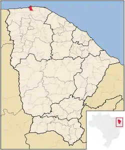 Location of Jijoca de Jericoacoara in Ceará | |
| Country | Brazil |
| Region | Northeast |
| State | Ceará |
| Founded | May 6, 1991 |
| Government | |
| • Mayor | Sergio Herrero Gimenez (PSDB) |
| Area | |
| • Total | 201.858 km2 (77.938 sq mi) |
| Elevation | 22 m (72 ft) |
| Population (2020 [1]) | |
| • Total | 20,087 |
| • Density | 82.5/km2 (214/sq mi) |
| Time zone | UTC-03:00 |
| Website | http://www.jijocadejericoacoara.ce.gov.br |
Name
The word Jericoacoara comes from Tupi (an indigenous language) and means "lair of turtles (îurukûá means "sea turtle" and kûara means "lair, hole")."
History
A fact of some historical significance is the report of Vicente Yáñez Pinzón (Captain of Nau Niña, the fleet of Christopher Columbus), which anchored in the bay of Jericoacoara in 1499.[3] But this was not official at the time as a result of the Treaty of Tordesillas, which was signed in the same year.
References
- IBGE 2020
- "Aeroporto de Jericoacoara no Ceará é inaugurado com voo comercial vindo de Congonhas". 24 June 2017. Retrieved 11 November 2017.
- "Jericoacoara's Guide". visitejericoacoara.com. Retrieved 2009-06-03.
| Wikimedia Commons has media related to Jijoca de Jericoacoara. |
This article is issued from Wikipedia. The text is licensed under Creative Commons - Attribution - Sharealike. Additional terms may apply for the media files.