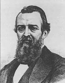
José Salazar Ilarregui
José Salazar Ilarregui (September 25 1823[1] - May 9 1892) was Governor of Yucatan during the Second Mexican Empire of Maximilian of Habsburg.[2] He worked in the Mexican Commission of Borders between Mexico-U.S in 1848, and Mexico-Guatemala in 1878-1885.
José Salazar Ilarregui | |
|---|---|
 | |
| Governor of Yucatan Imperial Commissary of Yucatan | |
| In office September 4 1864 – March 25 1866 | |
| Preceded by | Felipe Navarrete |
| Succeeded by | Domingo Bureau |
| In office November 10 1866 – June 15 1867 | |
| Preceded by | Domingo Bureau |
| Succeeded by | Manuel Cepeda Peraza |
| Minister of State | |
| In office March 8 1866 – June 15 1866 | |
| Monarch | Maximilian of Habsburg |
| Preceded by | José Fernando Ramírez |
| Succeeded by | José María Lacunza |
| Minister of Development, Colonization, Industry and Commerce | |
| In office July 26 1866 – September 14 1866 | |
| Monarch | Maximilian of Habsburg |
| Preceded by | Francisco Somera |
| Succeeded by | Joaquín de Mier y Terán |
| In office June 13 1864 – August 21 1864 | |
| Succeeded by | Manuel Ruiz |
| Personal details | |
| Born | September 25 1823 Mexico City |
| Died | May 9 1892 Mexico City |
| Political party | Conservative |
| Mother | Francisca Velázquez y Obregón |
| Father | Francisco Salazar Ilarregui |
Treaty of Limits between Mexico and the United States
José Salazar was a surveyor of the Mexican Commission of Borders Matamoros Section of the peace treaty that was signed in the sacristy of the Basilica of Guadalupe in Mexico City on February 2, 1848, and was called Treaty of Peace, Friendship, Limits and Settlement between the United States of America and the Mexican Republic. This document specified the border between the two countries, which included the loss to Mexico of more than half of its territory, which would be added to the United States.
The Mexican Commission of Borders was integrated by:[3]
First stage
| Name | Function |
|---|---|
| Pedro García Conde | Commissioner |
| José Salazar Ilarregui | Surveyor |
| Francisco Jiménez | Engineer First class |
| Francisco Martínez de Chavero | Secretary of the Commission |
| Ricardo Ramírez Agustín García Conde |
Engineers Second class |
| Felipe de Iturbide | Interpreter and translator |
Second stage
| Name | Function |
|---|---|
| Pedro García Conde | Commissioner |
| José Salazar Ilarregui | Surveyor |
| Francisco Jiménez Agustín García Conde |
Engineers First class |
| Francisco Martínez de Chavero | Secretary of the Commission |
| Ricardo Ramírez Juan B. Espejo |
Engineers Second class |
| Felipe de Iturbide | Interpreter and translator |
| Agustín Díaz | Surveyor |
| Manuel Fernández Miguel Iglesias Ignacio Molina Manuel Alemán Luis Díaz Antonio Contreras |
Engineers Third class |
References
- Geographers: Biobibliographical Studies; Patrick H. Armstrong, Geoffrey Martin
- "Gobierno - Yucatán". 2 June 2007. Archived from the original on 2 June 2007.
- Tamayo Pérez, Luz María Oralia. 1994. “José Salazar Ilarregui, personaje central de la Comisión de Límites Mexicana y dos de sus colaboradores: Francisco Jiménez y Agustín Díaz”. Coordinación por María Luisa Rodríguez-Sala, 215-242. México: UNAM.