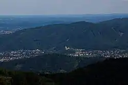
Judendorf-Straßengel
Judendorf-Straßengel is a former municipality in the district of Graz-Umgebung in the Austrian state of Styria. Since the 2015 Styria municipal structural reform, it is part of the municipality Gratwein-Straßengel.[2]
Judendorf-Straßengel | |
|---|---|
 | |
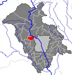 Location within Graz-Umgebung district | |
 Judendorf-Straßengel Location within Austria | |
| Coordinates: 47°06′46″N 15°20′04″E | |
| Country | Austria |
| State | Styria |
| District | Graz-Umgebung |
| Government | |
| • Mayor | Harald Mulle (SPÖ) |
| Area | |
| • Total | 10.61 km2 (4.10 sq mi) |
| Elevation | 380 m (1,250 ft) |
| Population (1 January 2016)[1] | |
| • Total | 5,851 |
| • Density | 550/km2 (1,400/sq mi) |
| Time zone | UTC+1 (CET) |
| • Summer (DST) | UTC+2 (CEST) |
| Postal code | 8111 |
| Area code | 03124 |
| Vehicle registration | GU |
| Website | www.gemeinde-judendorf-strassengel.at |
History
The town was first mentioned in the year AD 860 as Strazinolum.[3]
Sights
The fourteenth century Gothic Pilgrimage Church Maria Straßengel that stands on a hill overlooking the town was constructed between 1346 and 1355, and contains an important high altar.[3]
Economy
The town also has a rehab clinic, a chemical plant, and a punching tool factory.[3]
Tourism
Straßengel attracts 23,774 overnight stays in tourism. Plankenwarth Castle is located nearby.[3]
References
- Statistik Austria - Bevölkerung zu Jahresbeginn 2002-2016 nach Gemeinden (Gebietsstand 1.1.2016) for Judendorf-Straßengel.
- Die neue Gemeindestruktur der Steiermark
- "Judendorf-Straßengel". Encyclopedia of Austria. Retrieved 13 October 2013.
| Authority control |
|---|
This article is issued from Wikipedia. The text is licensed under Creative Commons - Attribution - Sharealike. Additional terms may apply for the media files.