Köte
A Köte (also Köthe) is the term used in the Harz Mountains of central Germany for a charcoal burner's hut (Köhlerhütte). A Köte was occupied by a charcoal burner in order to look after a nearby wood pile (Kohlenmeiler). The charcoal burner prepared the necessary charcoal for the smelting of ores.[1]

A Köte and Kohlenmeiler with charcoal burners at their work (turn of the 19th/20th century)
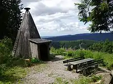
A Köte and rest area on the Schindelkopf
Today, Köten are used for tourism purposes as shelters and rest stops for hikers.
Examples
There are replicas of Köten in the Harz, for example at these places:
- Köte am Heidenstieg (51°50′26.7″N 10°25′24.3″E), in the Schulenberg Forest northwest of and above Schulenberg im Oberharz between the Großer (645.4 m) and Kleiner Wiesenberg (512.5 m above sea level (NHN)) at about 521 m[2] on the Heidenstieg; as No. 124[2] in the system of checkpoints in the Harzer Wandernadel hiking network
- Köte am Schindelkopf (51°43′23″N 10°20′11″E), in the Osterode Municipal Forest east of Osterode am Harz on the northwestern slopes of the Schindelkopf (ca. 629 m above sea level (NHN)) at about 570 m[3] on the Nassen Weg; as No. 143[3] in the system of checkpoints of the Harzer Wandernadel
Gallery
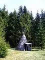 Typical Köte in the Harz
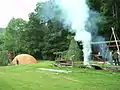 Completed Meiler with wind break, charcoal hut and fireplace
References
- Informationstafel Eine Köte… (Foto), auf jensunterwegs.de
- Köte am Heidenstieg:
– Topographische Karte mit Wegabzweig bei der Köte am Heidenstieg Archived 2016-04-20 at the Wayback Machine [südöstlich unterhalb eines Wasserbehälters (Wbh); ungefähre Höhenlage der Köte laut Höhenlinie/n in AK 5/2,5], auf natur-erleben.niedersachsen.de
– Harzer Wandernadel: Stempelstelle 124 / Köte am Heidenstieg, auf harzer-wandernadel.de - Köte am Schindelkopf:
– Topographische Karte mit zwei Wegabzweigen bei der Köte am Schindelkopf Archived 2016-04-20 at the Wayback Machine [auf dem Bergnordwesthang; ungefähre Höhenlage der Köte laut Höhenlinie/n in AK 5/2,5], auf natur-erleben.niedersachsen.de
– Harzer Wandernadel: Stempelstelle 143 / Köte Schindelkopf, auf harzer-wandernadel.de
This article is issued from Wikipedia. The text is licensed under Creative Commons - Attribution - Sharealike. Additional terms may apply for the media files.