K-108 (Kansas highway)
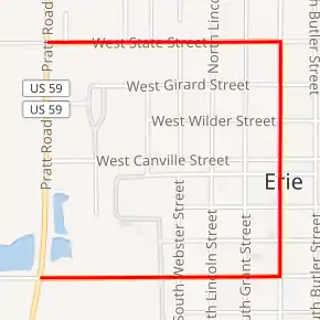
K-108 was a 1.500-mile-long (2.414 km) state highway in the U.S. state of Kansas. K-108's southern terminus was at U.S. Route 59 (US-59) in Erie, and the northern terminus was at US-59 in Erie.
| ||||
|---|---|---|---|---|
K-108 highlighted in red | ||||
| Route information | ||||
| Maintained by KDOT | ||||
| Length | 1.500 mi[1] (2.414 km) | |||
| Existed | August 28, 1946[2]–July 19, 2004[3] | |||
| Major junctions | ||||
| South end | ||||
| North end | ||||
| Location | ||||
| Counties | Neosho | |||
| Highway system | ||||
| ||||

K-108 was first established as a state highway in 1946, as a spur from a new alignment of US-59 to the Erie city line. In 1960, K-108 was extended east, then north, then west to US-59. This created a complete loop through Erie off US-59. Then K-108 was removed from the state highway system in a 2004 resolution.
Route description
K-108 began at US-59 and began travelling east along West 4th Street. After about .5 miles (0.80 km), it reached South Main Street, where it turned north. It continued north through the city, before reaching First Street, where it changed to North Main Street. It then continued north to State Street, then turned west. It continued along State Street for .5 miles (0.80 km) then terminated back at US-59.
The Kansas Department of Transportation (KDOT) tracks the traffic levels on its highways, and in 2004, they determined that on average the traffic varied from 1490 vehicles near the southern terminus to 2320 vehicles near the northern terminus.[4] K-108 was not included in the National Highway System.[5] The National Highway System is a system of highways important to the nation's defense, economy, and mobility.[6]
History
Before 1946, US-59 ran directly north–south through Erie. Then on August 28, 1946, K-108 was established as a state highway from a new alignment of US-59 to Erie.[2] In a November 10, 1960 resolution, K-108 was extended east, then north, then west to US-59 and K-57. This created a complete loop through Erie off US-59.[7] The Kansas Department of Transportation removed K-108 from the state highway system in a July 19, 2004 resolution.[3]
Major intersections
The entire route was in Erie, Neosho County.
| mi[1] | km | Destinations | Notes | ||
|---|---|---|---|---|---|
| 0.000 | 0.000 | Southern terminus | |||
| 1.500 | 2.414 | Northern terminus | |||
| 1.000 mi = 1.609 km; 1.000 km = 0.621 mi | |||||
References
- Staff (2016). "Pavement Management Information System". Kansas Department of Transportation. Retrieved April 16, 2017.
- Kansas State Highway Commission (August 28, 1946). "Resolution for relocation and redesignation of road in Neosho County". Topeka: Kansas State Highway Commission. Retrieved April 21, 2020.
- Kansas Department of Transportation (July 19, 2004). "Resolution to withdraw K-108 from the State Highway System in Neosho County". Topeka: Kansas Department of Transportation. Retrieved April 21, 2020.
- Bureau of Transportation Planning (2004). Traffic Flow Map Kansas State Highway System (PDF) (Map). [c. 1:1,584,000]. Topeka: Kansas Department of Transportation. Retrieved April 22, 2020.
- Federal Highway Administration (May 8, 2019). National Highway System: Kansas (PDF) (Map). [c. 1:3,900,000]. Federal Highway Administration. Retrieved April 22, 2020.
- Natzke, Stefan; Neathery, Mike; Adderly, Kevin (September 26, 2012). "What is the National Highway System?". National Highway System. Federal Highway Administration. Retrieved April 22, 2020.
- Kansas State Highway Commission (November 10, 1960). "Resolution for addition to the State Highway System". Topeka: Kansas State Highway Commission. Retrieved April 21, 2020.