K-129 (1980–1997 Kansas highway)
K-129 was a 0.446-mile-long (0.718 km) state highway in the U.S. state of Kansas. K-129's southern terminus was at K-154 in Dodge City and the northern terminus was at U.S. Route 56 (US-56), US-283 and US-50 Business (US-50 Bus.) in Dodge City.
| ||||
|---|---|---|---|---|
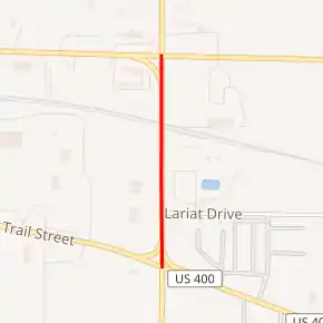
Former K-129 highlighted in red | ||||
| Route information | ||||
| Maintained by KDOT | ||||
| Length | 0.446 mi[1] (0.718 km) | |||
| Existed | August 12, 1980[1]–c. 1996[2][3] | |||
| Major junctions | ||||
| South end | ||||
| North end | ||||
| Location | ||||
| Counties | Ford | |||
| Highway system | ||||
| ||||

K-129 was first designated as a state highway in 1980, replacing US-154 Spur. Then in 1994, when US-400 was created, K-129 was decommissioned and became a part of a newly rerouted US-56, US-283 and US-400.
Route description
K-129 began at K-154 and started travelling north, and soon intersected Lariat Drive. It continued north for a short distance, crossed the railroad tracks, then reached its northern terminus at US-56, US-283 and US-50 Business.
The Kansas Department of Transportation (KDOT) tracks the traffic levels on its highways, and in 1995, they determined that on average the traffic was 6420 vehicles on K-129.[2]
History
The highway that became K-129 was first designated as US-154 Spur in a December 22, 1948 resolution.[4] In an August 12, 1980 resolution, U.S. 154 Spur was decommissioned and became K-129.[1] In a December 5, 1994 resolution, it was planned to decommission K-129 and make it a part of a newly rerouted US-56, US-283 and US-400, once other parts of US-400 wer built.[5] Then by 1996, K-129 had been decommissioned and became part of the new alignment of US-56, US-283 and US-400.[2][3]
Major intersections
The entire route was in Dodge City, Ford County.
| mi | km | Destinations | Notes | ||
|---|---|---|---|---|---|
| 0.000 | 0.000 | Southern terminus | |||
| 0.400 | 0.644 | Northern terminus | |||
| 1.000 mi = 1.609 km; 1.000 km = 0.621 mi | |||||
References
- State Highway Commission of Kansas (August 12, 1980). "Resolution to redesignate a US Numbered Route as a K Numbered Route". Topeka: State Highway Commission of Kansas. Retrieved May 1, 2020.
- Bureau of Transportation Planning (1995). Traffic Flow Map Kansas State Highway System (PDF) (Map). [c. 1:1,584,000]. Topeka: Kansas Department of Transportation. Retrieved May 1, 2020.
- Bureau of Transportation Planning (1996). Traffic Flow Map Kansas State Highway System (PDF) (Map). [c. 1:1,584,000]. Topeka: Kansas Department of Transportation. Retrieved May 1, 2020.
- State Highway Commission of Kansas (August 12, 1980). "Resolution for establishment of road in Ford County". Topeka: State Highway Commission of Kansas. Retrieved May 1, 2020.
- State Highway Commission of Kansas (December 5, 1994). "State Highway Resolution to establish highway U.S. 400 in thirteen counties in Kansas". Topeka: State Highway Commission of Kansas. Retrieved May 1, 2020.