K-256 (Kansas highway)
K-256 is a state highway in the U.S. state of Kansas. The highway runs 4.989 miles (8.029 km) from U.S. Route 56 (US-56) west of Marion to US-77 east of Marion in central Marion County. K-256 directly serves the city of Marion, the county seat of Marion County. The highway was established in 1985.
| ||||
|---|---|---|---|---|
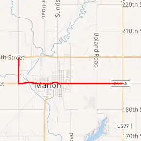
K-256 highlighted in red | ||||
| Route information | ||||
| Maintained by KDOT and the city of Marion | ||||
| Length | 4.989 mi[1] (8.029 km) | |||
| Existed | 1985[2]–present | |||
| Major junctions | ||||
| North end | ||||
| East end | ||||
| Highway system | ||||
| ||||

Route description
.jpg.webp)
K-256 begins at US-56 between Hillsboro and the US-56–US-77–K-150 roundabout east of Marion. The highway heads south and crosses the Cottonwood River. At the next junction of section line roads, K-256 turns east and crosses the river again at the west city limit of Marion. The highway continues along Main Street and enters the downtown area after its grade crossing of a Union Pacific Railroad line. K-256 passes to the south of the historic Bown-Corby School and Elgin School and north of the Marion County Courthouse. The route crosses Mud Creek and passes the historic Hill Grade School. K-256 passes through an S-curve at Cedar Street then heads straight east out of town. The highway passes to the north of Marion Municipal Airport and the Civilian Conservation Corps–constructed Marion County Lake before reaching its eastern terminus at US-77 1 mile (1.6 km) south of the US-56–US-77–K-150 junction between Florence and Lincolnville.[3][4]
History
The Kansas Department of Transportation authorized the addition of K-256 to the state highway system through a November 8, 1985, resolution.[2]
K-256 first appeared on the 1991-92 KDOT state map. It follows a former US-56 alignment through Marion. It was formed when a bypass of both Hillsboro and Marion was completed.[5]
As of January 2013, KDOT has proposed transferring the mileage of K-256 to Marion County.[6]
Major intersections
The entire route is in Marion County.
| Location | mi[1] | km | Destinations | Notes | |
|---|---|---|---|---|---|
| | 0.000 | 0.000 | Western terminus | ||
| | 4.989 | 8.029 | Eastern terminus | ||
| 1.000 mi = 1.609 km; 1.000 km = 0.621 mi | |||||
References
- Staff (2016). "Pavement Management Information System". Kansas Department of Transportation. Retrieved May 6, 2017.
- Office of the Secretary of Transportation (November 8, 1985). "Resolution for Designation of a Portion of Two F.A.S. Routes and a City Connecting Link in Marion County". Kansas Department of Transportation. Retrieved May 6, 2017.
- Bureau of Transportation Planning (January 2007). City of Marion (PDF) (Map). KDOT City Maps. Topeka, KS: Kansas Department of Transportation. Retrieved May 6, 2017.
- Bureau of Transportation Planning (April 2017). General County Highway Maps (half inch) (PDF) (Map). 1:125,000. Topeka, KS: Kansas Department of Transportation. Retrieved May 6, 2017.
- Kansas Department of Transportation: Historic State Maps,
- Stewart, Adam (January 30, 2013). "State requests county takeover". Marion County Record.