K-292 (Kansas highway)
K-292 was a 0.750-mile-long (1.207 km) state highway in the U.S. state of Kansas. K-292's western terminus was at K-92 northeast of the unincorporated community of Springdale and the eastern terminus was at K-92 northeast of Springdale.
| ||||
|---|---|---|---|---|
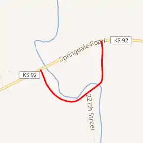
Former K-292 highlighted in red | ||||
| Route information | ||||
| Length | 0.750 mi[1] (1.207 km) | |||
| Existed | December 12, 1945[2]–June 22, 1960[1] | |||
| Major junctions | ||||
| West end | ||||
| East end | ||||
| Location | ||||
| Counties | Leavenworth | |||
| Highway system | ||||
| ||||
.svg.png.webp)
K-292 was established in 1945 as a state highway, to serve the former covered bridge that crossed Stranger Creek, which was an old alignment of K-92. After the bridge, built in 1858, burned down in 1958, K-292 was removed from the highway system in 1960.
Route description
K-292 began at K-92 northeast of Springdale. It began travelling southeastward, on what is now 227th Street, through a forested area along Stranger Creek, a tributary of the Kansas River. It then curved northeastward and crossed the creek via the former covered bridge. It continued past the bridge for a short distance before terminating back at K-92.
History
.jpg.webp)
K-292 was established on December 12, 1945 as a state highway. Its purpose was to serve the old covered bridge that crossed Stranger Creek, which was an old alignment of K-92.[2] After the bridge burned down, K-92 was removed from the highway system in a June 22, 1960 resolution.[1]
In 1858, General Albert Sydney Johnston, commander at Fort Leavenworth, had four covered bridges constructed across Stranger Creek. The bridges cost about $1500 each and were constructed at Easton, Farmington, Jarbalo and Springdale. The other three were removed in the 1930s. It was later abandoned for a few years before the State Highway Commission starting a restoration project in 1946, including a new roof and siding. Then on September 21, 1958, the bridge was struck by lightning and burned down.[3]
Major intersections
The entire route was in Alexandria Township, Leavenworth County.
| mi[1] | km | Destinations | Notes | ||
|---|---|---|---|---|---|
| 0.000 | 0.000 | Western terminus | |||
| 0.750 | 1.207 | Eastern terminus | |||
| 1.000 mi = 1.609 km; 1.000 km = 0.621 mi | |||||
References
- State Highway Commission of Kansas (June 22, 1960). "Resolution for removal of road in Leavenworth County". Topeka: State Highway Commission of Kansas. Retrieved April 22, 2020.
- State Highway Commission of Kansas (December 12, 1945). "Resolution for addition of road in Leavenworth County". Topeka: State Highway Commission of Kansas. Retrieved April 22, 2020.
- lostbridges.org (2018). "Springdale, Leavenworth County". Topeka: lostbridges.org. Retrieved April 22, 2020.