K-57 (Kansas highway)
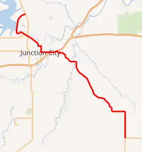
K-57 is a 31.2-mile-long (50.2 km) state highway in the U.S. state of Kansas. It is a north-south highway that connects Junction City to Milford Lake, as well as serving as a southeasterly connection to Council Grove. The highway's mileposts are signed the wrong way; generally the mileage starts at the southern or western terminus. However, the mileposts begin at the northern terminus.
| ||||
|---|---|---|---|---|
K-57 highlighted in red | ||||
| Route information | ||||
| Maintained by KDOT and the city of Junction City | ||||
| Length | 31.200 mi[1] (50.212 km) | |||
| Major junctions | ||||
| South end | ||||
| North end | ||||
| Location | ||||
| Counties | Geary, Morris | |||
| Highway system | ||||
| ||||

Route description
K-57 begins at K-4 in Dwight and proceeds north. It exits Morris County 2 miles (3.2 km) north of Dwight and into Geary County and heads northwest, running parallel with Dry Creek. It then crosses Clarks Creek and proceeds northwest into Grandview Plaza. It then reaches a partial interchange with I-70, with eastbound entrance and westbound exit, and begins and overlap with US-40 Bus.. The highway turns west and begins to parallel I-70. It then reaches a junction with J Hill Road, which provides access to westbound I-70. The highway then crosses Smoky Hill River and enters Junction City. At North Washington street K-57 turns north and US-40 Bus. turns south. Northwest of Junction City, the highway then intersects US-77 and then runs concurrently with K-244 for 0.4 miles (0.64 km). The route continues west and then heads north crossing over the Republican River and passing by Curtis Creek until reaching its northern terminus at US-77 east of Milford Lake.[2]
The entire section of K-57 within Junction City is maintained by the city.[3]
History
K-57 first appeared on the map in 1932.[4] The highway was once much longer, and spanned a large portion of eastern Kansas. The southern terminus was at the Missouri border southeast of Pittsburg on what is current-day K-171. Much of the old alignment is now county-owned roads, and after being moved to other, overlapping highways over the years, last appeared on the 2003-2004 map.[5]
Major junctions
| County | Location | mi[1] | km | Destinations | Notes |
|---|---|---|---|---|---|
| Morris | Dwight | 0.000 | 0.000 | Southern terminus; road continues south as K-4 west | |
| Geary | Grandview Plaza | 19.623 | 31.580 | Southern end of US-40 Bus. concurrency; no access to I-70/US-40/K-18 west; I-70 exit 300 | |
| 20.523 | 33.029 | To I-70 exit 299 | |||
| Junction City | 22.126 | 35.608 | Northern end of US-40 Business concurrency | ||
| | 25.785 | 41.497 | Eastern terminus of K-244; southern end of K-244 concurrency | ||
| | 26.151 | 42.086 | Northern end of K-244 concurrency; no southbound access to K-244 west, no northbound access from K-244 east | ||
| | 27.552 | 44.341 | Northern terminus of K-244 Spur | ||
| | 31.200 | 50.212 | Northern terminus | ||
1.000 mi = 1.609 km; 1.000 km = 0.621 mi
| |||||
References
- Staff (2016). "Pavement Management Information System". Kansas Department of Transportation. Retrieved April 22, 2017.
- Kansas Department of Transportation (2015). There's No Place Like Kansas: Official State Transportation Map (PDF) (Map) (2015–16 ed.). Scale not given. Topeka: Kansas Department of Transportation. Retrieved August 12, 2015.
- Kansas Department of Transportation (January 2, 2003). "Resolution Designating City Connecting Links in State Highway System". Topeka: Kansas Department of Transportation. Retrieved January 4, 2021.
- State Highway Commission of Kansas (1932). Kansas Official Highway Map (PDF) (Map). Scale not given. Topeka: State Highway Commission of Kansas. Retrieved August 12, 2015.
- Kansas Department of Transportation (2003). Kansas The Real Experience: Official State Transportation Map (PDF) (Map) (2003–04 ed.). Scale not given. Topeka: Kansas Department of Transportation. Retrieved August 12, 2015.