Kafia Kingi
The Kafia Kingi (Arabic: كافيا كنجي) area is a mineral-rich region on the border between Sudan, South Sudan and the Central African Republic. It is disputed between South Sudan and Sudan.
Kafia Kingi كافيا كنجي | |
|---|---|
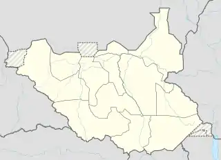 Kafia Kingi كافيا كنجي Location in South Sudan | |
| Coordinates: 9.273123°N 24.417404°E | |
| Country | Disputed |
| Area | |
| • Total | 4,800 sq mi (12,500 km2) |
| Population | |
| • Estimate (2010)[1] | 16,000 |
| Time zone | GMT+3 |
The area was due to be given to South Sudan under the terms of the 2005 Comprehensive Peace Agreement which required use of the Sudan "north–south line" as of 1 January 1956.[1] It was not until 1960 that the Kafia Kingi area was transferred north of that line and added to Darfur. Sudan controls all or most of this area today, though at times since independence South Sudan forces have briefly controlled large portions.[2]
Almost all of Kafia Kingi (except a southern portion south of the Umblasha River) is within the borders of the Sudanese Radom National Park, a biosphere reserve, of which two-thirds are also within the borders of Kafia Kingi, while another one-third of the National Park is within the Sudanese region of South Darfur.
Warlord Joseph Kony is thought to be hiding in Kafia Kingi.[3]
The Kafia Kingi region is a known haven for ivory smugglers. Congolese ivory is frequently held in Kafia Kingi before being taken north into Darfur.[4]
References
- Thomas, Edward (2010). The Kafia Kingi Enclave: People, politics and history in the north–south boundary zone of western Sudan. London: Rift Valley Institute. ISBN 978-1-907431-04-3.
- Sudan Supporting Kony, group Says The Boston Globe, April 27, 2013
- Joseph Kony's rebels sell ivory, minerals: report The Associated Press, November 19, 2014
- "Tracking the Illegal Tusk Trade". www.nationalgeographic.com. Retrieved 2016-01-04.