Kalamunda Zig Zag
The Kalamunda Zig Zag was a zig zag rail line that was part of the Upper Darling Range Railway line in Western Australia, opening in July 1891 and closing in July 1949. It was converted to a public road in 1952, and is now a tourist drive that offers views of Perth from the hills.[1]
| Kalamunda Zig Zag | |
|---|---|
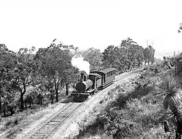 G class on the Zig Zag in 1937 | |
| Overview | |
| Status | Converted to a public road |
| Termini | Ridge Hill Gooseberry Hill |
| Service | |
| Type | Zig Zag railway |
| System | Western Australian Government Railways |
| Technical | |
| Line length | 3 kilometres |
| Track gauge | 1,067 mm (3 ft 6 in) |
History
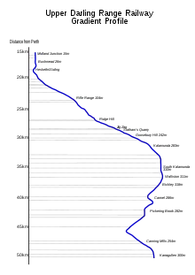
The Kalamunda Zig Zag was completed in July 1891, as part of the Upper Darling Range Railway line in Western Australia which was built by the Canning Jarrah Timber Company from a junction with the Midland line at Midland Junction to Canning Mills to transport railway sleepers to Perth's growing railway system. On 1 July 1903, the line was taken over by the Western Australian Government Railways.[2][3]
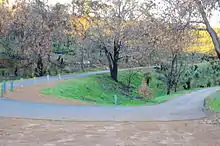
To overcome a steep gradient up the Darling Scarp, a zig zag was built between Ridge Hill and Gooseberry Hill stations, being cheaper to build than a continuous gradient line. It closed on 22 July 1949 along with the rest of the line, with the track removed in 1952 and converted into a narrow bitumen road. The road is one-way for most of the Zig Zag, and is not recommended for hiking.[2][3][4]
In 2019 a submission to the WA State Government was being prepared for redevelopment of the Zig Zag.[5] The City of Kalamunda temporarily closed the road in May 2020 due to reports of anti-social behaviour at the road at night including dangerous driving, drug use and animal abuse. The road is not expected to reopen until February 2021.[1]
Sections
The sections of the railway that made up the zig zag were:
- Ridge Hill (lower section of Zig Zag)
- Number 1 Points
- Number 2 Points Statham's Quarry known also as Perth City Council Siding from 1920
- Number 3 Points
- Number 4 Points (upper section of Zig Zag)
The gradient was as steep as 1 in 27 with an average of 1 in 38.[2]
Events
Every year the City of Kalamunda holds a Zig Zag Walk event, in which the Zig Zag is closed to all but pedestrians, providing people with the opportunity to admire the views and see the area's wildflowers; the Zig Zag is a part of the Darling Range Regional Park. The Zig Zag Walk occurs around early October every year.[6] On the last Sunday of October each year, there is a community Arts Festival called the Zig Zag Festival held in Stirk Park, Kalamunda.[7]
The Zig Zag is also used as a stage in the Targa West Rally. The road is closed to all traffic and the stage is run in reverse road direction, from the bottom to the top.[8]
References
- Historic Perth Zig Zag road closed amid concerns about drugs, violence and animal cruelty
- Bromby, Robyn (1988). Australian Rail Annual 1988. Sutherland: Sherbourne Sutherland Publishing. pp. 115–120. ISBN 1 86275 004 1.
- History of the Railway Pickering Brook Heritage Group
- Kalamunda Zig Zag Trail Rail Trails
- Kalamunda Zig Zag redevelopment website
- Walk the Zig Zag Shire of Kalamunda
- Zig Zag Festival Shire of Kalamunda
- Stage Maps Targa West
Further reading
- Steele, Ken.(1993) Zig Zag to Kalamunda : the story of the Upper Darling Range Railway Lesmurdie, W.A.: Drillmark Publications Division. ISBN 0-646-16323-X
- Watson, Lindsay The Railway History Of Midland Junction : Commemorating The Centenary Of Midland Junction, 1895-1995 Swan View, W.A : L & S Drafting in association with the Shire of Swan and the Western Australian Light Railway Preservation Association 1995
External links
 Media related to Kalamunda Zig Zag at Wikimedia Commons
- Zig Zag Community Arts Festival page