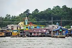
Kampong Ayer
Kampong Ayer is a historic settlement area in Bandar Seri Begawan, the capital of Brunei. It literally means 'water village' (Malay: Kampung Air). Kampong Ayer consists of a cluster of traditional stilt villages built on the Brunei River, mainly in the vicinity of the present-day Pusat Bandar or the City Centre.[2][3] Hence, it has often been dubbed as 'Venice of the East' since the past.[4][3] Kampong Ayer has been historically the principal settlement of Brunei; it was the de facto capital, in particular social and economic centre, of the Bruneian Empire for a few centuries, but also extending into the early period during British imperialism in Brunei.
Kampong Ayer
Kampung Ayer | |
|---|---|
 | |
| Nickname(s): | |
 | |
| Coordinates: 4°52′57″N 114°56′33″E | |
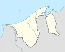
| Country | Brunei |
| Mukim | |
| Population | |
| • Estimate (2011)[1] | 13,000 |
Name
The present name 'Kampong Ayer' is the old romanised spelling of the Malay term 'Kampung Air', which is literally translated as 'Water Village'. However, the old spelling version is retained and still used as the primary name of the place.
History
Kampong Ayer is believed to have been inhabited for several centuries. There are several historical records, particularly foreign sources, which reported the existence of 'water settlements' on the Brunei River. The most well known is arguably the account by Antonio Pigafetta, an Italian explorer, on his visit to Brunei as part of the Magellan fleet in 1521,[5] in which he described the settlement as
entirely built in salt water... It contains twenty-five thousand hearths (families). The houses are all constructed of wood and built up from the ground on tall pillars.
— Antonio Pigafetta, European Sources for the History of the Sultanate of Brunei in the Sixteenth Century, p. 11
There is a possibility that the stilt settlement might not have always been where it is today, that Kampong Ayer might have undergone relocation throughout history. Olivier van Noort, a Dutch, on his stay in Brunei from December 1600 to January 1601, described the houses (of the nobles) as
made of wood, and built on such light piles that when there is a storm or some other untoward event these houses can be removed from one side of the river to the other.
— Olivier van Noort, European Sources for the History of the Sultanate of Brunei in the Sixteenth Century, p. 96
The stilt settlement of what we know today as Kampong Ayer had always been the primary settlement area of the de facto capital of the Bruneian Empire for centuries.[6] However, the role also extended into the time from the arrival, and subsequent imperial presence of the British even until the early 20th century. It was only during the Residential period that a programme which encouraged the Kampong Ayer residents to resettle on land began to be introduced, although it was initially unsuccessful but eventually took off, resulting in significant reduction to its population. Nevertheless, substantial number of residents still remain to live on water. Kampong Ayer also survived bombardments during World War II.[7]
Administration
Kampong Ayer consists of several small neighbourhoods which are officially designated as villages, the third- and lowest-level administrative divisions of Brunei; each has its own village head (Malay: ketua kampung). The villages are under a few mukims (subdistricts) of Brunei-Muara District, with penghulu as the mukim head. The mukims and villages administration in Kampong Ayer are overseen by the Brunei-Muara District Office.
Subdivisions
| Mukim[8] | Villages[9] |
|---|---|
| Burong Pingai Ayer | Burong Pingai Ayer, Lurong Dalam, Pandai Besi 'A', Pandai Besi 'B', Pekan Lama, Pengiran Setia Negara, Sungai Pandan 'A', Sungai Pandan 'B' |
| Peramu | Bakut Berumput, Bakut Pengiran Siraja Muda 'A', Bakut Pengiran Siraja Muda 'B', Lurong Sikuna, Pekilong Muara, Peramu, Setia Pahlawan Lama |
| Saba | Saba Darat 'A', Saba Darat 'B', Saba Laut, Saba Tengah, Saba Ujong |
| Sungai Kebun | Bolkiah 'A', Bolkiah 'B', Setia 'A', Setia 'B', Sungai Kebun, Sungai Siamas, Ujong Kelinik |
| Tamoi | Pengiran Bendahara Lama, Pengiran Kerma Indera Lama, Pengiran Tajuddin Hitam, Tamoi Tengah, Tamoi Ujong |
Until recently, there used to be another mukim division in Kampong Ayer, that is Sungai Kedayan. However, the mukim and its constituent villages have ceased to exist, due to the redevelopment project on parts of the Kedayan River which coincided with the settlements. The residents have been relocated elsewhere in other parts of Kampong Ayer or on land. The area has been redeveloped as a riverfront park,[10] which has been inaugurated to the public in October 2017 as part of the Golden Jubilee celebration of Sultan Hassanal Bolkiah's ascension to the throne.[11]
Infrastructure
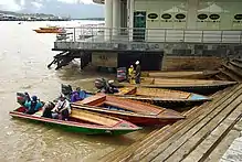
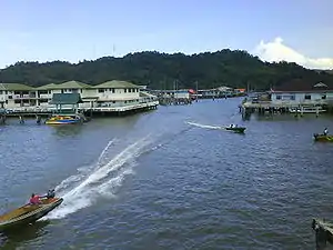
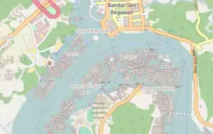
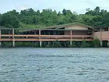
The houses, thus villages, of Kampong Ayer are interconnected with bridges and walkways,[3] wooden and concrete, creating contiguous areas. Thus, accessibility among many villages are possible by foot. Among non-contiguous areas and where the villages are not located along the riverbanks, these areas are accessible by water transport, whereby the most common transport mode is the 'water taxis' (Malay: perahu tambang).[3] They are wooden motorboats which transport anyone, at fares, among jetties in the villages and along the riverbanks in its vicinity.
Similar to public housing developments on land, Kampong Ayer has also a few public housing areas, in the form of stilt houses. The most recent development is the pilot project in upgrading Kampong Ayer, which saw the construction of single- and double-storey houses in the Saba and Peramu areas.[12]
Common utilities are available in Kampong Ayer, which include may electricity, pipe water, telephone lines, internet access and television services.[2]
Educational institutions are available in Kampong Ayer which provide public education comprising primary, primary religious and secondary. There are at least a primary school in each mukim. Similarly, religious schools can also be found, which provide primary religious education to the resident Muslim pupils. The secondary school in Kampong Ayer, Awang Semaun Secondary School, is the only school of its kind where its buildings are built on water. Nevertheless, Sayyidina Umar Al-Khattab Secondary School, which is built on land, also has catchment area in some villages of Kampong Ayer.
There are mosques which serve the need of the Muslim residents for Islamic congregational activities, in particular the Jumu'ah or Friday prayers.
For security and emergency services, there are police stations and fire departments. The latter plays a very significant role, as fire cases are common in Kampong Ayer, in which the main causes include faulty wiring and susceptibility of houses and infrastructures to fire due to many are built with wood.[13]
Challenges
Survival
As a major historical and cultural heritage of Brunei, there has been increasing concern on the survival of Kampong Ayer in modern times. This is factored by the emigration and relocation of the inhabitants to land. Over the last few decades, the overall population has been shrinking, estimated to have decreased from about 28,000 in 1981 to 13,000 in 2011.[1] The diminishing population, added with the busy modern lifestyle, are threatening the survival of the customs and traditions practiced in Kampong Ayer. It also weakens the sense of community among the residents.[1]
Waste
The floating of rubbish and sewage on the waters of Kampong Ayer is a persisting issue despite substantial measures and initiatives taken by various government and non-government agencies.[14] It is acknowledged that the sources of the problem are not simply from within Kampong Ayer but may also due to ineffective waste management on land, specifically in the vicinity of upstream tributaries and streams of the Brunei River, in which Kampong Ayer lay along its downstream flow.[15] Measures have been implemented by the government which include upgrading and installation of sewage treatment works in the catchment areas, as well as installation of rubbish collection system in the villages of Kampong Ayer.[15][16] However, complete success is still yet to be seen. Systematic sewage disposal in Kampong Ayer itself is only feasible on public housing villages, namely Bolkiah 'A', Bolkiah 'B' and Sungai Bunga, where they have organised residential layout, where as in the traditional villages, which constitute the majority of Kampong Ayer areas, such disposal system is still not yet available.[15]
Non-government organisations also play significant roles in combatting this issue. Together with the government, as well as the general public, in particular the Kampong Ayer residents, multiple cleaning campaigns have been conducted.[14] Awareness programmes to the public on the importance of waste management have also been carried out for many years.[15] Again, the effectiveness of such programmes have yet to completely yield the desired results.
References
- Mat Sani, Khai Zem. "Kampong Ayer Research". apb.ubd.edu.bn. Retrieved 2017-12-13.
- "Kampong Ayer (Water Village)". Archived from the original on 2018-06-19. Retrieved 2017-12-13.
- Road Map and Street Index of Brunei Darussalam. p. 34. ISBN 9991790101.
- Welcome to Brunei Darussalam : the complete traveller's guide ([1st ed.] ed.). [Bandar Seri Begawan, Brunei Darussalam]: Brunei Press. 2000. p. 23. ISBN 9991732055. OCLC 48517132.
- Nicholl, Robert (ed.) (2007). European sources for the history of the Sultanate of Brunei in the sixteenth century (Third ed.). [Bandar Seri Begawan]: Brunei Museums Department. p. 8. ISBN 978-9991730318. OCLC 930264554.CS1 maint: extra text: authors list (link)
- Yunos, Rozan (2009-01-18). "Retracing history of streets of Bandar". The Brunei Times. Archived from the original on 2016-08-21. Retrieved 2016-07-18.
- S. C. Chi (1994). The changing socio-economic profile of Kampong Ayer, Negara Brunei Darussalam. Faculty of Arts and Social Sciences, Universiti Brunei Darussalam. p. 65.
- "Brunei-Muara District" (PDF). p. 8. Retrieved 2017-12-13.
- "Geoportal - Survey Department". survey.gov.bn. Retrieved 2017-12-13.
- Jimi-Ha. "LOCAL NEWS". 3g.modasys.net. Archived from the original on 2017-10-23. Retrieved 2017-12-13.
- "His Majesty launches Taman Mahkota Jubli Emas – Borneo Bulletin Online". Borneo Bulletin Online. 2017-10-23. Retrieved 2017-12-13.
- "Projek Perintik Menaik Taraf Kampung Ayer" (PDF). Retrieved 2017-12-13.
- "War on Kampong Ayer fire – Borneo Bulletin Online". Borneo Bulletin Online. 2017-06-16. Retrieved 2017-12-13.
- "Kg Ayer's long drawn battle with rubbish". Green Brunei. 2016-04-25. Retrieved 2017-12-13.
- "Department of Environment, Park and Recreation - Don't Destroy Our River". www.env.gov.bn. Retrieved 2017-12-13.
- Masli, Arifubillah. "Kg Ayer's rubbish impossible to eliminate, says JASTRe". modasys.net. Retrieved 2017-12-13.
| Wikimedia Commons has media related to Kampong Ayer (Water Village). |
| Wikivoyage has a travel guide for Kampong Ayer. |