Kana (river)
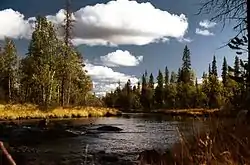
The Kana (Russian: Кана) is a river in the southwestern part on the Kola Peninsula, Murmansk Oblast, Russia. The Kana is a tributary to the Umba. It is 48 kilometres (30 mi) long, and has a drainage basin of 284 square kilometres (110 sq mi).[1] It has its sources in the forests southeast of Lake Imandra, about 25 km south of the town of Apatity. From there it flows in a southeasterly direction, through a largely uninhabited landscape dominated by forests and bogs. Its outlet is at the northern end of Lake Kanozero on the Umba River.
| Kana | |
|---|---|
 | |
| Location | |
| Country | Russia |
| Physical characteristics | |
| Mouth | Lake Kanozero |
• coordinates | 67.1314°N 33.9987°E |
| Length | 48 km (30 mi) |
| Basin size | 284 km2 (110 sq mi) |
| Basin features | |
| Progression | Lake Kanozero→ Umba→ White Sea |
References
- Река Кана in the State Water Register of Russia (Russian)
- Topographical map 1:200,000 (Map) (1992 ed.). Russian Federation, Murmansk Oblast. § 12, 13, 22.
This article is issued from Wikipedia. The text is licensed under Creative Commons - Attribution - Sharealike. Additional terms may apply for the media files.