Kanjiroba Himal
The Kanjiroba Himal is an isolated part of the Himalaya range within Nepal, adjacent to the Tibetan border.
| Kanjiroba | |
|---|---|
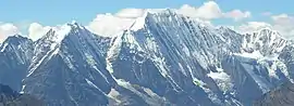 Photo of Kanjiroba Himal, a sub-range himalaya in Dolpa, Nepal | |
| Highest point | |
| Elevation | 6,883 m (22,582 ft) [1] |
| Prominence | 1,870 m (6,140 ft) [1] |
| Listing | Ultra |
| Coordinates | 29°22′42″N 82°38′21″E [1] |
| Geography | |
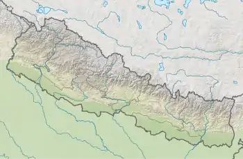 Kanjiroba Location in Nepal | |
| Location | Nepal |
| Parent range | Kanjiroba Himal, Himalayas |
The region remained unmapped until the 1950s, when British explorer John Baird Tyson made the first of a series of expeditions to the area.[2]
The highest peak is Kanjiroba with a summit elevation of 6,883 meters above sea level.
Location
Kanjiroba Himal is within the cross-border Shey Phoksundo National Park,Dolpa district,Nepal about 180 kilometres north-west of Pokhara city.
Geology
The region is high mountains, cut into by glaciers and deep, precipitous river valleys.
Communications
Limited to the valleys, there are no practicable routes across the high mountains into Tibet
References
- "High Asia II: Himalaya of Nepal, Bhutan, Sikkim and adjoining region of Tibet". Peaklist.org. Retrieved 2015-02-16.
- "John Tyson - obituary". Daily Telegraph. 13 March 2014. Retrieved 31 March 2014.
This article is issued from Wikipedia. The text is licensed under Creative Commons - Attribution - Sharealike. Additional terms may apply for the media files.