Kham Thale So District
Kham Thale So (Thai: ขามทะเลสอ, pronounced [kʰǎːm tʰā.lēː sɔ̌ː]) is a district (amphoe) of Nakhon Ratchasima Province, northeastern Thailand.
Kham Thale So
ขามทะเลสอ | |
|---|---|
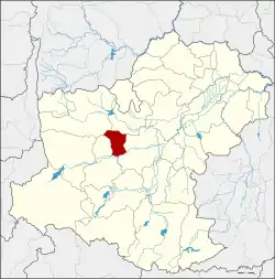 District location in Nakhon Ratchasima Province | |
| Coordinates: 14°57′39″N 101°56′51″E | |
| Country | Thailand |
| Province | Nakhon Ratchasima |
| Seat | Kham Thale So |
| Area | |
| • Total | 203.6 km2 (78.6 sq mi) |
| Population (2000) | |
| • Total | 28,306 |
| • Density | 139.0/km2 (360/sq mi) |
| Time zone | UTC+7 (ICT) |
| Postal code | 30280 |
| Geocode | 3019 |
History
The government separated some parts of Non Thai and Sung Noen Districts and created the minor district (king amphoe) Kham Thale So in 1958, which was upgraded to a full district in 1965.
Geography
Neighbouring districts are (from the north clockwise) Non Thai, Mueang Nakhon Ratchasima, Sung Noen, and Dan Khun Thot.
Administration
The district is divided into five sub-districts (tambons). Kham Thale So is also a township (thesaban tambon) which covers parts of the tambon Kham Thale So.
| 1. | Kham Thale So | ขามทะเลสอ | |
| 2. | Pong Daeng | โป่งแดง | |
| 3. | Phan Dung | พันดุง | |
| 4. | Nong Suang | หนองสรวง | |
| 5. | Bueng O | บึงอ้อ |
Economy
The district is the site of salt mines operated by the Saltworks Company, a major producer of salt for the chemical and food industries.[1]
References
- Tangprasert, Prasit (13 June 2016). "Salt mine protests intensify". Bangkok Post. Retrieved 13 June 2016.
This article is issued from Wikipedia. The text is licensed under Creative Commons - Attribution - Sharealike. Additional terms may apply for the media files.