Khatanga (river)
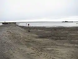
The Khatanga (Russian: Хатанга) is a river in Krasnoyarsk Krai in Russia. It begins at the confluence of the rivers Kotuy and Kheta. The Khatanga is 227 kilometres (141 mi) long (1,636 km (1,017 mi) including its headwater Kotuy);[1] the area of its basin is 364,000 square kilometres (141,000 sq mi).[2] It flows into the Khatanga Gulf of the Laptev Sea, forming an estuary. There are more than 112,000 lakes, with a total surface area of 11,600 square kilometres (4,500 sq mi), in the basin of the river.
| Khatanga | |
|---|---|
 | |
| Location | |
| Country | Russia |
| Physical characteristics | |
| Source | confluence of Kotuy and Kheta |
| Mouth | Laptev Sea |
• coordinates | 73°11′14″N 106°12′25″E |
| Length | 227 km (141 mi) |
| Basin size | 364,000 km2 (141,000 sq mi) |
| Basin features | |
| Tributaries | |
| • left | Kheta, Novaya, Malaya Balakhnya |
| • right | Kotuy, Nizhnyaya, Bludnaya, Popigay |
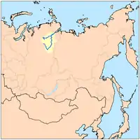
The Khatanga freezes up in late September–early October and breaks up in early June. Its main tributaries are the Nizhnyaya, Bludnaya, Popigay, Novaya, and Malaya Balakhnya. The Khatanga teems with different kinds of fish, including ryapushka, omul, muksun, white salmon, taimen, loach, and others. The river is navigable. The river port of Khatanga is located on the river.
See also
- List of largest unfragmented rivers
- Katanga, name for the upper course of the river Podkamennaya Tunguska
References
- Река Хатанга (Котуй, Сейси) in the State Water Register of Russia (Russian)
- Хатанга, Great Soviet Encyclopedia
- Armstrong, Terence (2010). Russian Settlement in the North. Cambridge University Press.