Khlong Mon
Khlong Mon (Thai: คลองมอญ, pronounced [kʰlɔ̄ːŋ mɔ̄ːn]) is a khlong (canal) in Bangkok's Thonburi side. Khlong Mon is a natural khlong and delineates the border between Bangkok Yai and Bangkok Noi Districts. It has a starting point, separated from the west bank of the Chao Phraya River at the area beside the Royal Thai Navy Council through Khlong Ban Khamin, which is the original city moat since Thonburi was the capital. Then linked to Khlong Bang Khun Si or Khlong Chak Phra, which is the original Chao Phraya River after that continues as far as Wat Ko temple. At its Wat Ko end, it splits into two courses: Khlong Bang Noi (upper) and Khlong Bang Chueak Nang (lower) in the area of Taling Chan and Phasi Charoen Districts.
| Khlong Mon | |
|---|---|
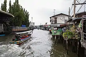 Long-tail boat sailing in the khlong | |
| Specifications | |
| Length | 3 km (1.9 miles) |
| Geography | |
| Start point | Bangkok |
| End point | Bangkok |
| Connects to | Chao Phraya River, Khlong Bang Khun Si, Khlong Bang Noi, Khlong Bang Chueak Nang |
Its name comes from the Mon settlement located along the route. However, it has other names – Khlong Bang Sao Thong (คลองบางเสาธง), Khlong Bang Noi (คลองบางน้อย) etc.
Although it is a short route only 3 km (1.9 mi) long, Khlong Mon is important in the aspect of history. Including as a cultural tourism route, as well as Khlong Bangkok Yai.[1]
References
- Banchun, Ong (2009-02-18). "ชุมชนมอญในประเทศไทย - คลองมอญ กรุงเทพฯ" [Mon community in Thailand - Khlong Mon Bkk]. OPENBASE (in Thai). Retrieved 2019-06-15.