Kieta
Kieta is a port town located on the eastern coast of the island of Bougainville in Papua New Guinea, near the township of Arawa. After extensive destruction during the 1990 Civil Uprising on Bougainville, Kieta has few inhabitants now, and is known mainly for its transport connections (wharf and airfield).
Kieta | |
|---|---|
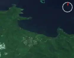 The city of Arawa, and the port of Kieta, from space | |
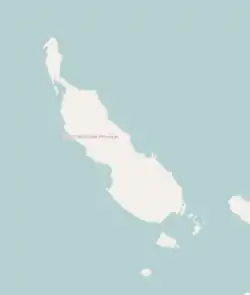 Kieta Location within Bougainville Island | |
| Coordinates: 06°12′57″S 155°37′58″E | |
| Country | Papua New Guinea |
| Province | Bougainville |
| District | Central Bougainville |
| LLG | Arawa Rural LLG |
| Time zone | UTC+10 (AEST) |
| Location | 12 km (7.5 mi) from Arawa |
| Mean max temp | 32 °C (90 °F) |
| Mean min temp | 23 °C (73 °F) |
| Annual rainfall | 3,037 mm (119.6 in) |
History
On 17 May 1885, agreements were made between Germany and the United Kingdom over the islands of Bougainville and Buka in the area of the German sphere of interest. On 20 September 1905 a station was built with a post office and customs. Since 1902, there was a Catholic mission station in Kieta.[1]
Kieta was occupied by the Japanese during the Second World War.
The majority of the town was destroyed in the 1990 Civil Uprising on Bougainville.[2][3] The airfield has a 5,400 feet (1,600 m) runway which was used by the Japanese in World War II, and was recently serviced by Air Niugini until 1990. Since then, the only aircraft to service the area have been the Royal Australian Air Force and Royal New Zealand Air Forces (C130 Hercules) in support of the Peace Monitoring Group.
A number of Papuan languages are spoken in the Kieta district, such as Naasioi.
Climate
Kieta has a mean maximum temperature of 32 °C (90 °F), mean minimum temperature of 23 °C (73 °F), and annual rainfall of 3,037 mm (119.6 in).
References
- Bougainville History
- Pacific Wrecks
- Melanesian stories: Marist Brothers in Solomon Islands and Papua New Guinea 1845-2003. Lawrence McCane. 2004. p. 346. ISBN 9980-85-421-9. Retrieved July 10, 2010.