Kintla Peak
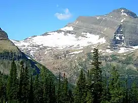
Kintla Peak (10,106 ft (3,080 m)) is part of the Livingston Range in Glacier National Park in the U.S. state of Montana.[4] It is the tallest mountain in the Livingston Range and the third tallest in Glacier National Park.[1] It is also the most northerly peak and land area in the contiguous United States above 10,000 ft (3,000 m). The Agassiz Glacier lies below it to the southeast.[4][5]
| Kintla Peak | |
|---|---|
 Kintla Peak at right above Agassiz Glacier | |
| Highest point | |
| Elevation | 10,106 ft (3,080 m) [1] NAVD 88 |
| Prominence | 4,401 ft (1,341 m) [1] |
| Parent peak | Mount Cleveland |
| Coordinates | 48°56′38″N 114°10′16″W[2] |
| Geography | |
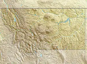
 Kintla Peak Location in Montana  Kintla Peak Location in the United States | |
| Location | Flathead County, Montana, U.S. |
| Parent range | Livingston Range |
| Topo map | USGS Kintla Peak, MT |
| Geology | |
| Age of rock | Precambrian (Mesoproterozoic)[3] |
| Climbing | |
| Easiest route | Scramble (Class 3/4), often some snow |
Kintla Peak consists of ancient Precambrian (Mesoproterozoic) rock strata that are part of the Belt Supergroup.[3] It is named after the Kintla Lakes, and the word "Kintla" originates from the Kootenai word for "sack". Kootenai legend states that a man had apparently drowned in one of the lakes and likened the lake to a sack where "once you got in, you couldn't get out".[6]
Kintla Peak lies the remote northwest corner of the park and a hike of almost 15 miles (24 km) from the nearest road is required just to reach the base of the mountain. The peak is notable for its large rise above local terrain; the elevation of nearby Upper Kintla Lake is only 4,370 feet (1,330 m). (Kintla Peak's northern neighbor Kinnerly Peak has an even more dramatic drop to Upper Kintla Lake.) This helps make Kintla "the most arduous climb in the northwest section of the park".[7] The standard route is the Southeast Ridge Route, from the Agassiz Glacier basin. This route has a long approach and a large total vertical gain, and involves rock scrambling up to Class 4, in addition to some climbing on snow, depending on the season. Other routes include the East Ridge, West Face, and Upper North Face routes.
References
- "Kintla Peak, Montana". Peakbagger.com. Retrieved October 5, 2014.
- "Kintla Peak". Geographic Names Information System. United States Geological Survey. Retrieved October 5, 2014.
- Alt, D.D. and Hyndman, D.W. 1986. Roadside geology of Montana. Mountain Press Publishing Co., Missoula, Montana, 427 p. ISBN 0-87842-202-1.
- Kintla Peak, MT (Map). TopoQwest (United States Geological Survey Maps). Retrieved October 5, 2014.
- Gildart, Bert (1990). Glacier Country: Montana's Glacier National Park. Farcountry Press. p. 12. ISBN 9780938314387. Retrieved January 1, 2015.
- Arguimbau, Ellie; Baumler, Ellen; Porsild, Ellen; Shovers, Brian (2009). Montana Place Names from Alzada to Zortman. Montana Historical Society. p. 142. ISBN 9780975919613. Retrieved January 1, 2015.
- Edwards, J. Gordon (January 1, 1991). A Climber's Guide to Glacier National Park. Guilford CT: Falcon Press. p. 89. ISBN 0-87842-177-7.