Kiokio railway station
Kiokio railway station was a flag station on the North Island Main Trunk in New Zealand.[2][3]
Kiokio railway station | |||||||||||
|---|---|---|---|---|---|---|---|---|---|---|---|
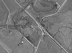 Kiokio in 1944 | |||||||||||
| Location | New Zealand | ||||||||||
| Coordinates | 38.153255°S 175.239658°E | ||||||||||
| Elevation | 36 m (118 ft) | ||||||||||
| Line(s) | North Island Main Trunk | ||||||||||
| Distance | Wellington 498.86 km (309.98 mi) | ||||||||||
| History | |||||||||||
| Opened | 9 March 1887 | ||||||||||
| Closed | 28 November 1971 goods, 9 June 1969 passenger[1] | ||||||||||
| Electrified | June 1988 | ||||||||||
| Services | |||||||||||
| |||||||||||
By December 1896 there was a shelter shed, platform, cart approach and a crossing loop for 4 wagons. By December 1911 a loading bank had been added and the loop extended for 7 wagons.[4] In 1913 traffic at the station was described as, "rapidly increasing" and the Minister for Railways approved a goods shed 30 ft (9.1 m) by 20 ft (6.1 m) with a verandah over a new siding.[5] A 1963 report said the station building was built in 1887 and last painted in 1960. It closed to passengers on Monday, 9 June 1969 and to all traffic on Sunday, 28 November 1971.[6] There is now just a single track through the station site and, apart from the name of the road, little sign that there was ever a station.[7]
References
- Juliet Scoble: Names & Opening & Closing Dates of Railway Stations in New Zealand
- New Zealand Railway and Tramway Atlas (First ed.). Quail Map Co. 1965. pp. 3 & 4.
- Pierre, Bill (1981). North Island Main Trunk. Wellington: A.H&A.W Reed. pp. 289–290. ISBN 0589013165.
- "Stations" (PDF). NZR Rolling Stock Lists. Retrieved 10 August 2020.
- King Country Chronicle, Volume VII, Issue 590, 2 August 1913, Page 5 KIO KIO RAILWAY STATION. GOODS SHED PROVIDED
- "Stations" (PDF). NZR Rolling Stock Lists. Retrieved 10 August 2020.
- "Kio Kio Station Rd". Google Maps. Retrieved 18 January 2021.
External links
- 1931 derailment of 14 wagons about a mile north of Kiokio - report and photo
- CFG Heritage: Te Awamutu Reinforcement Project – archaeological assessment
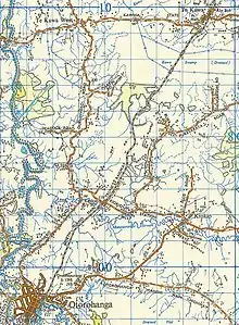
Figures 28 and 29 map and photo of probable location of Kiokio goods shed