Kitti (municipality)
Kitti also written as Kiti, is one of the twelve administrative divisions of the Micronesian state of Pohnpei. it is located in the southwest of Pohnpei island, to the south of Mount Nanlaud.
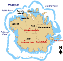
Map of Pohnpei Island showing the municipalities.
Education
Pohnpei State Department of Education operates public schools:
See also
Climate
Kitti has a tropical rainforest climate (Af) with very heavy rainfall year-round.
| Climate data for Kitti | |||||||||||||
|---|---|---|---|---|---|---|---|---|---|---|---|---|---|
| Month | Jan | Feb | Mar | Apr | May | Jun | Jul | Aug | Sep | Oct | Nov | Dec | Year |
| Average high °C (°F) | 29.4 (85.0) |
29.8 (85.6) |
30.1 (86.2) |
29.8 (85.7) |
30.3 (86.6) |
29.9 (85.9) |
29.6 (85.3) |
29.6 (85.2) |
29.7 (85.4) |
29.9 (85.9) |
30.2 (86.4) |
29.6 (85.3) |
29.8 (85.7) |
| Daily mean °C (°F) | 26.5 (79.7) |
26.8 (80.2) |
26.8 (80.3) |
26.8 (80.2) |
27.1 (80.8) |
26.8 (80.2) |
26.3 (79.3) |
26.3 (79.4) |
26.4 (79.6) |
26.6 (79.8) |
26.8 (80.3) |
26.6 (79.8) |
26.7 (80.0) |
| Average low °C (°F) | 23.6 (74.4) |
23.8 (74.8) |
23.6 (74.5) |
23.7 (74.7) |
23.9 (75.0) |
23.6 (74.5) |
22.9 (73.3) |
23.1 (73.6) |
23.2 (73.8) |
23.2 (73.7) |
23.4 (74.2) |
23.5 (74.3) |
23.5 (74.2) |
| Average rainfall mm (inches) | 441.5 (17.380) |
331.5 (13.050) |
378.5 (14.900) |
504.2 (19.850) |
493.3 (19.420) |
496.1 (19.530) |
501.4 (19.740) |
556.3 (21.900) |
517.1 (20.360) |
544.1 (21.420) |
420.1 (16.540) |
411.0 (16.180) |
5,595.1 (220.27) |
| Source: [2] (rainfall) | |||||||||||||
References
- "Pohnpei Schools." Pohnpei State Department of Education. Retrieved on February 23, 2018.
- https://www.wrcc.dri.edu/cgi-bin/cliMAIN.pl?pi4705
- Bendure, G., & Friary, N. (1988) Micronesia: A travel survival kit. South Yarra, Australia: Lonely Planet.
This article is issued from Wikipedia. The text is licensed under Creative Commons - Attribution - Sharealike. Additional terms may apply for the media files.