Kiya (river)
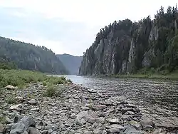
The Kiya (Russian: Ки́я) is a river in Tomsk and Kemerovo Oblasts of Russia. It is a left tributary of the Chulym (in the Ob's drainage basin), and is 548 kilometres (341 mi) long, with a drainage basin of 32,200 square kilometres (12,400 sq mi).[1] The river has its sources in the Kuznetsky Alatau and flows in a northwesterly direction to its mouth in the Chulym some 40 kilometres (25 mi) upriver from the town of Asino.
| Kiya | |
|---|---|
 | |
| Location | |
| Country | Russia |
| Physical characteristics | |
| Mouth | Chulym |
• coordinates | 56.8531°N 86.665°E |
| Length | 548 km (341 mi) |
| Basin size | 32,200 km2 (12,400 sq mi) |
| Basin features | |
| Progression | Chulym→ Ob→ Kara Sea |
Its main tributaries are from the right: Tyazhin and Chet, and from the left: Kozhakh and Antibes.
The town of Mariinsk lies along the Kiya.
This article is issued from Wikipedia. The text is licensed under Creative Commons - Attribution - Sharealike. Additional terms may apply for the media files.