La Cumbre Peak
La Cumbre Peak is a 3,997-foot (1,218 m) peak in the Santa Ynez Mountains north of Santa Barbara, California. Made up of boulders and slabs of the Matilija Sandstone amid groves of pine trees, it is the highest summit near to the city.[3] Other peaks in the Santa Ynez Range are Santa Ynez Peak, 15 miles (24 km) to the west, and Divide Peak, 15 miles (24 km) to the east.
| La Cumbre Peak | |
|---|---|
 La Cumbre Peak Location in California  La Cumbre Peak La Cumbre Peak (the United States) | |
| Highest point | |
| Elevation | 3,997 ft (1,218 m) NAVD 88[1] |
| Prominence | 1,010 ft (310 m) [2] |
| Coordinates | 34°29′40″N 119°42′45″W [1] |
| Geography | |
| Location | Santa Barbara County, California, U.S. |
| Parent range | Santa Ynez Mountains |
| Topo map | USGS Santa Barbara |
| Climbing | |
| Easiest route | Road |
The road to the top, East Camino Cielo, is frequently used by runners and cyclists for training, as the elevation gain is substantial and sustained, while there is relatively little car traffic.
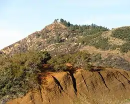
La Cumbre Peak, viewed from the east. While the mountain is composed of Matilija Sandstone, a prominent outcrop of the Juncal Formation is in the foreground.
References
- "Near La Cumbre". NGS data sheet. U.S. National Geodetic Survey. Retrieved 2014-03-04.
- "La Cumbre Peak, California". Peakbagger.com. Retrieved 2014-03-04.
- Norris, Robert M. (2003). The geology and landscape of Santa Barbara County, California. Santa Barbara, California: Santa Barbara Museum of Natural History. pp. 80–81. ISBN 0-936494-35-2.
External links
This article is issued from Wikipedia. The text is licensed under Creative Commons - Attribution - Sharealike. Additional terms may apply for the media files.