Laaxer Stöckli
The Laaxer Stöckli (also known as Piz Grisch) is a 2,898 metre-high mountain of the Glarus Alps, located on the border between the cantons of Glarus and Graubünden in Eastern Switzerland. It lies approximately halfway between the Vorab and Piz Segnas.
| Laaxer Stöckli | |
|---|---|
| Piz Grisch | |
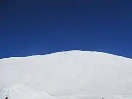 The summit seen from La Siala | |
| Highest point | |
| Elevation | 2,898 m (9,508 ft) |
| Prominence | 271 m (889 ft) [1] |
| Parent peak | Piz Segnas |
| Coordinates | 46°52′59″N 9°12′15″E |
| Geography | |
 Laaxer Stöckli Location in Switzerland | |
| Location | Glarus/Graubünden, Switzerland |
| Parent range | Glarus Alps |
The Laaxer Stöckli belongs to the municipalities of Glarus Süd and Laax. The closest localities are Elm and Flims. The south side is part of the Flims-Laax ski area. A chairlift reaches La Siala at a height of 2,806 metres.
References
- Retrieved from the Swisstopo topographic maps. The key col is the Pass dil Segnas (2,627 m).
This article is issued from Wikipedia. The text is licensed under Creative Commons - Attribution - Sharealike. Additional terms may apply for the media files.