Lachapelle Bridge
'Lachapelle Bridge', in French Pont Lachapelle, (1930 and 1975) Also known as Cartierville Bridge.
Lachapelle Bridge | |
|---|---|
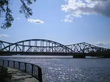 The twin spans of Lachapelle Bridge, seen from the Montreal (down stream) side. | |
| Coordinates | 45°31′58″N 73°43′41″W |
| Carries | 6 lanes of Route 117 (3 lanes per span) |
| Crosses | Rivière des Prairies |
| Locale | Montreal and Laval |
| Maintained by | The city of Laval |
| Characteristics | |
| Total length | 262.43 metres (861 ft) |
| Width | 15.5 metres (51 ft) (northbound) |
| History | |
| Opened | May 24, 1930 (northbound) 1975 (southbound) |
| Statistics | |
| Daily traffic | 38,000 (2013)[1] |
| Location | |
| |
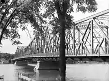
Older bridge in 1948
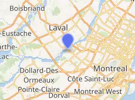
This bridge spans the Rivière des Prairies between the Montreal borough of Ahuntsic-Cartierville and the Laval (Île Jésus) neighbourhood of Chomedey.
Actually there are two bridges, side by side and parallel:
The older (1930) three lane span, on the down stream side, carries the traffic north into Laval.
The newer (1975) three lane span, on the up stream side, carries the traffic south into Montreal.
Except for the length and the distance between the piers, the two spans are not identical.
A wooden bridge was originally built there in 1836, replaced by a steel one, built in 1882.
See also
- List of bridges spanning the Rivière des Prairies
- List of crossings of the Rivière des Prairies
References
- Bisson, Bruno. "Pont de l'A-25: ça roule pour le MTQ". La Presse. Retrieved 25 June 2014.
External links
Crossings of the Rivière des Prairies | ||||
|---|---|---|---|---|
| ||||
This article is issued from Wikipedia. The text is licensed under Creative Commons - Attribution - Sharealike. Additional terms may apply for the media files.