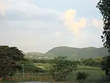
Lajas Valley
The Lajas Valley (Spanish: Valle de Lajas) runs east-to-west in southwestern Puerto Rico, within the municipalities of Lajas, Cabo Rojo, Guánica, and Sabana Grande.[1][2] It is surrounded by the Cordillera Central and the Santa Marta hills to the north, the Sierra Bermeja (a small range in Lajas and Cabo Rojo), the Boqueron Bay in Cabo Rojo, and Guánica Bay. The climate is considered moist to dry subhumid tropical.[1] Its large extension and fertile soil has made it a good place for agriculture. However, it is one of the driest places of Puerto Rico, making irrigation necessary. A Tethered Aerostat Radar System aerostat is located at the Lajas Valley.

Seismological research in 2005 determined there is an ancient fault, the South Lajas Valley fault (SLVF), in the vicinity.[3]
References
- Graves, Robert P. (1991). "GROUND-WATER RESOURCES IN LA JAS VALLEY, PUERTO RICO" (PDF). USGS. Retrieved 11 January 2020.
Water-Resources Investigations Report 89-4182
- "Elevation of Lajas,Puerto Rico Elevation Map, Topo, Contour". FloodMap. FloodMap.net. Retrieved 11 January 2020.
- "Puerto Rico's Winter 2019-2020 Seismic Sequence Leaves the Island On Edge". Temblor. temblor.net. 7 January 2020. Retrieved 11 January 2020.
Prentice and Mann (2005)