Lake Abitibi
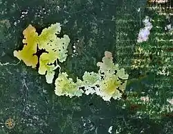
Lake Abitibi (French: Lac Abitibi) is a lake in northeastern Ontario and western Quebec, Canada. The lake, which lies within the vast Clay Belt, is separated in two distinct portions by a short narrows, making it actually 2 lakes. Its total area is 931 km², and net area 903 km².[1] The lake is shallow and studded with islands. Its shores and vicinity are covered with small timber.
| Lake Abitibi | |
|---|---|
 | |
 Lake Abitibi Location in Ontario and Quebec | |
| Location | Cochrane District, Ontario / Abitibi-Ouest Regional County Municipality, Quebec |
| Coordinates | 48°40′N 79°45′W |
| Primary outflows | Abitibi River |
| Basin countries | Canada |
| Surface area | 931 km2 (359 sq mi) |
| Average depth | 3.5 m (11 ft) |
| Max. depth | 15.0 m (49.2 ft) |
| Surface elevation | 265 m (869 ft) |
| Islands | over 900 |
Its outlet is the Abitibi River, a tributary of the Moose River, which empties into James Bay. The lake takes its name from the river. "Abitibi" comes from the Algonquin words abitah, meaning middle and nipi meaning water,[2] possibly a reference to its geographic location between the Harricana (from the Algonquin word Nanikana, meaning "the main way")[3] to the east and the Kapuskasing–Mattagami river system to the west.
European exploration

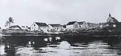
Application of Abitibi to describe the lake and the people living in the area around it was first noted in The Jesuit Relations in 1640.[4] One of the first Europeans in this area was Pierre de Troyes, who built a post on Lake Abitibi when he was on his way to capture English HBC posts on James Bay in 1686.[5] The Abitibi Post lay halfway between trading posts on James Bay and those on the Ottawa River. It was formerly used by the Hudson's Bay Company (HBC) as part of a canoe route to the fur lands of the north. A HBC trading post was located on the east shore of the lake in Ontario.[6] The construction of the Grand Trunk Pacific Railway (now Canadian National Railway) through this district made it of some importance at the start of the 20th century.
Portions of Lake Abitibi's western shores and a section of the Abitibi River are part of the Abitibi-de-Troyes Provincial Park.
See also
- Wahgoshig First Nation
- Blake River Megacaldera Complex
- List of lakes in Ontario
Notes
- Atlas of Canada Archived 2007-04-10 at the Wayback Machine
- Hoiberg, Dale H., ed. (2010). "Abitibi River". Encyclopædia Britannica. I: A-ak Bayes (15th ed.). Chicago, IL: Encyclopædia Britannica Inc. pp. 33. ISBN 978-1-59339-837-8.
- Environnement Québec, North Harricana River Aquatic Reserve|http://www.mddep.gouv.qc.ca/biodiversite/aquatique/harricana-nord/note-en.pdf Online version
- Francis, Daniel. "Lake Abitibi". The Canadian Encyclopedia. Retrieved March 17, 2014.
- "The Canadian Encyclopedia". Archived from the original on 2007-09-30. Retrieved 2007-01-22.
- Lake Abitibi Post Archived 2011-07-06 at the Wayback Machine Canadian Heritage Gallery
References
 This article incorporates text from a publication now in the public domain: Chisholm, Hugh, ed. (1911). "Abitibbi". Encyclopædia Britannica. 1 (11th ed.). Cambridge University Press.