Lamb House, Kangaroo Point
Lamb House is a heritage-listed villa at 9 Leopard Street, Kangaroo Point, Queensland, Australia. It was designed by Alexander Brown Wilson and built from c. 1902 to c. 1908. It was added to the Queensland Heritage Register on 21 October 1992.[1]
| Lamb House | |
|---|---|
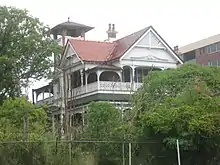
 Lamb House, from lower on the Kangaroo Point Cliffs | |
| Location | 9 Leopard Street, Kangaroo Point, Queensland, Australia |
| Coordinates | 27.4824°S 153.0323°E |
| Design period | 1900 - 1914 (early 20th century) |
| Built | c. 1902 - c. 1908 |
| Built for | John Lamb |
| Architect | Alexander Brown Wilson |
| Official name | Home, Lamb House |
| Type | state heritage (built, landscape) |
| Designated | 21 October 1992 |
| Reference no. | 600242 |
| Significant period | 1900s (fabric, historical) |
| Significant components | fence/wall - perimeter, views from, trees/plantings, residential accommodation - main house, garden/grounds, views to, tower - observation/lookout, gate - entrance |
| Builders | W Anthony |
 Location of Lamb House in Queensland  Lamb House, Kangaroo Point (Australia) | |
History

This substantial, two-storeyed brick residence was erected c. 1901 for John Lamb, co-proprietor of the successful Queen Street drapery establishment of Edwards & Lamb, and a businessman with enlightened attitudes toward his employees.[1]
The house was designed by established Brisbane architect Alexander Brown Wilson and was constructed over a twelve-month period by builder W Anthony at a contract price of £3,250.[1]
Kangaroo Point was Brisbane's earliest suburb, dating from the 1840s. From at least the 1860s, the higher land at Kangaroo Point attracted middle class residents who erected substantial homes overlooking the Brisbane River. The construction of this house in the early 1900s illustrates the continued attraction of this quiet but centrally located suburb for the middle class - a trend which was sustained into the 1920s.[1]
The house remains the property of the Lamb family.[1]
As of December 2020 the building has been unoccupied for several years, has had squatters, and is in disrepair. Repair could cost millions.[2] On 22 December 2020 the Brisbane City Council declared its intention to sell the property to recover several years of unpaid rates.[3] The land itself is worth A$6.1 million .[2]
Description
Lamb House is a large, two-storeyed, red brick residence with a multi-gabled roof clad in terracotta tiles. Conspicuously situated above the Kangaroo Point Cliffs at the southern end of the suburb, overlooking the South Brisbane and Town reaches of the Brisbane River, The house is an inner city landmark, prominent from many parts of the Brisbane central business district, the river and the Captain Cook Bridge and Pacific Motorway.[1]
Queen Anne influences are evident in the timber and roughcast gable infill designs, the ornate cement mouldings to the entrance portico- cum-observation tower, and the elaborate chimney stacks and tall terracotta chimney pots.[1]
Verandahs on three sides at both levels have timber posts, arches and weatherboard friezes.[1]
The original plans indicate vestibule and stairwell, dining, drawing and morning rooms, kitchen and service areas on the ground floor, and six bedrooms and a bathroom on the first floor.[1]
The residence has substantial grounds with mature trees and gardens. Wrought iron entrance gates and the decorative masonry fence to Leopard Street are original.[1]
Externally the building presents a highly intact Federation architecture period facade in a prominent riverside and garden setting.[1]
Heritage listing
Home was listed on the Queensland Heritage Register on 21 October 1992 having satisfied the following criteria.[1]
The place is important in demonstrating the evolution or pattern of Queensland's history.
Its construction illustrates the sustained development of Kangaroo Point as a residential suburb from the 1840s, and in particular the continued appeal to middle class residents of the high land overlooking the Brisbane River at Kangaroo Point, contributing to our understanding of residential and social hierarchies in Brisbane, and of the role of the Brisbane River within this structure.[1]
The place demonstrates rare, uncommon or endangered aspects of Queensland's cultural heritage.
Lamb House, erected c. 1902, is a rare surviving example of a grand, intact Federation period residence in the Brisbane district.[1]
The place is important in demonstrating the principal characteristics of a particular class of cultural places.
Lamb House is a most accomplished building in its architectural design, materials, workmanship and setting, and is significant as a major example of the domestic work of notable Brisbane architect Alexander B Wilson.[1]
The place is important because of its aesthetic significance.
The prominently situated residence has landmark quality and makes a strong aesthetic contribution to the townscape along the Kangaroo Point cliffs. Significant also are the views from Lamb House of the Brisbane River and central business district, which appear to have influenced the siting and design of the house.[1]
The place has a special association with the life or work of a particular person, group or organisation of importance in Queensland's history.
Lamb House is a most accomplished building in its architectural design, materials, workmanship and setting, and is significant as a major example of the domestic work of notable Brisbane architect Alexander B Wilson.[1]
References
- "Home (entry 600242)". Queensland Heritage Register. Queensland Heritage Council. Retrieved 1 August 2014.
- Pollard, Emma (8 December 2020). "Heritage-listed Brisbane mansion Lamb House faces uncertain future after racking up hefty council rates bill". www.abc.net.au. Australian Broadcasting Corporation. Retrieved 22 December 2020.
- Pollard, Emma (22 December 2020). "Brisbane mansion Lamb House to be sold by council over unpaid rates after years of uncertainty". www.abc.net.au. Australian Broadcasting Corporation. Retrieved 22 December 2020.
Attribution
![]() This Wikipedia article was originally based on "The Queensland heritage register" published by the State of Queensland under CC-BY 3.0 AU licence (accessed on 7 July 2014, archived on 8 October 2014). The geo-coordinates were originally computed from the "Queensland heritage register boundaries" published by the State of Queensland under CC-BY 3.0 AU licence (accessed on 5 September 2014, archived on 15 October 2014).
This Wikipedia article was originally based on "The Queensland heritage register" published by the State of Queensland under CC-BY 3.0 AU licence (accessed on 7 July 2014, archived on 8 October 2014). The geo-coordinates were originally computed from the "Queensland heritage register boundaries" published by the State of Queensland under CC-BY 3.0 AU licence (accessed on 5 September 2014, archived on 15 October 2014).
External links
| Wikimedia Commons has media related to Lamb House, Kangaroo Point. |