Lanes Creek Township, Union County, North Carolina
Lanes Creek Township, population 2,650, is one of nine townships in Union County, North Carolina. Lanes Creek Township is 46.48 square miles (120.4 km2)[1] in size and is located in southeast Union County. This township does not have any towns or cities within it.
Lanes Creek Township, Union County, North Carolina | |
|---|---|
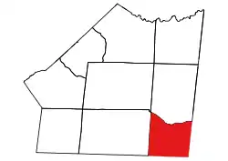 Location of Lanes Creek Township in Union County | |
 Location of Union County in North Carolina | |
| Country | United States |
| State | North Carolina |
| County | Union |
| Area | |
| • Total | 46.48 sq mi (128.38 km2) |
| Highest elevation [2] (southwest end of township) | 630 ft (190 m) |
| Lowest elevation [2] (Floodplain of Brown Creek of east side of township) | 324 ft (99 m) |
| Population (2010) | |
| • Total | 2,650[3] |
| • Density | 57.01/sq mi (22.01/km2) |
| Time zone | UTC-4 (EST) |
| • Summer (DST) | UTC-5 (EDT) |
| Area code(s) | 704 |
Geography
The northern and western parts of the township are drained by Lanes Creek and its tributaries, Waxhaw Branch, Carolina Creek, Wicker Branch and Norkett Branch. The southeast side is drained by Brown Creek and its tributary, Little Brown Creek. The northwestern side is drained by Rone Branch.[4]
References
- "NC OneMap". www.nconemap.gov. State of North Carolina. Retrieved 14 October 2020.
- "The National Map - Service Endpoints". viewer.nationalmap.gov. US Geological Survey. Retrieved 13 September 2020.
- "Census Bureau". data.census.gov. US Census Bureau. Retrieved 14 October 2020.
- "North Carolina Flood Hazard Area Effective". www.nconemap.gov. State of North Carolina. Retrieved 16 October 2020.
Municipalities and communities of Union County, North Carolina, United States | ||
|---|---|---|
| City | 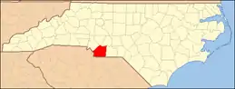 | |
| Towns | ||
| Villages | ||
| CDP | ||
| Unincorporated communities | ||
| Ghost town | ||
| Footnotes | ‡This populated place also has portions in an adjacent county or counties | |
| ||
This article is issued from Wikipedia. The text is licensed under Creative Commons - Attribution - Sharealike. Additional terms may apply for the media files.