Lapkalnys-Paliepiai Forest
The Lapkalnys-Paliepiai Forest (Lithuanian: Lapkalnio–Paliepių miškai) is a forest in Kėdainiai District Municipality and Raseiniai District Municipality, central Lithuania, located 8 kilometres (5.0 mi) to the north east from Ariogala. It covers an area of 3,710 hectares (9,200 acres). It consists of smaller forests: Juodžiai Forest, Lapkalnys Forest, Paliepiai Forest, Pašušvys Forest, Šilainiai Forest. It is on the watershed of the Dubysa (Gynėvė with Lendė and Upytė) and Nevėžis (Pečiupė, Ažytė, Ažynas, Raguva, Skerdūmė) rivers.
| Lapkalnys-Paliepiai Forest Lithuanian: Lapkalnio–Paliepių miškai | |
|---|---|
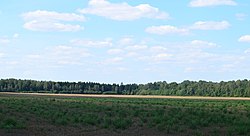 The forest at the surroundings of Užvarčiai | |
| Geography | |
 | |
| Location | Kėdainiai District Municipality, Raseiniai District Municipality, Lithuania |
| Coordinates | 55.366°N 23.600°E |
| Area | 37.1 km2 (14.3 sq mi) |
| Ecology | |
| Forest cover | birch, spruce, aspen |
| Fauna | wild boar, roe deer, red fox |
As of 2005, 48% of the area was covered by birch, 30% by spruce, 8% by aspen, 5% by ash, 3% by oak, 4% by black alder, 1% by white alder, 1% by pine, 1% by lime tree groups.[1] There is the Zembiškis Forest Botanical Sanctuary in the forest.
There are Lapkalnys, Skirgailinė, Zembiškis, Paskerdūmiukas, Šulcava, Graužai, Tilindžiai, Paliepiai, Žostautai, Juodžiai, Šliužiai, Daujotėliai, Paliepiukai villages inside the forest or on its edges.
Images
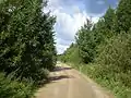 Pašušvys Forest - a part of the Lapkalnys-Paliepiai Forest
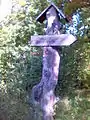 A wooden sign to the death place of Lithuanian resistants in Pašušvys Forest
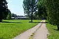 Lapkalnys village inside the forest
References
- Brukas, Algirdas (2007). Visuotinė lietuvių enciklopedija (in Lithuanian). 11. Vilnius: Mokslo ir enciklopedijų leidybos institutas. p. 528.