Lar, Uttar Pradesh
Lar is a town and a nagar panchayat in Deoria district in the Indian state of Uttar Pradesh. Lar is located at 26.2°N 83.97°E [1] and has an average elevation of 62 metres (203 feet).
Lar
Lar Bazar | |
|---|---|
Town | |
 Lar Location in Uttar Pradesh, India  Lar Lar (India) | |
| Coordinates: 26.2°N 83.97°E | |
| Country | |
| State | Uttar Pradesh |
| District | Deoria |
| Elevation | 62 m (203 ft) |
| Languages | |
| • Official | Hindi |
| Time zone | UTC+5:30 (IST) |
| PIN | |
| Vehicle registration | UP 52 |
| Website | up |
Demographics
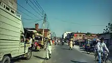
Lar Town Main Road
As of 2011 India census,[2] Lar had a population of 25,492. Males constitute 51% of the population and females 49%. Lar has an average literacy rate of 69%, lower than the national average of 74.04%: male literacy is 70%, and female literacy is 55%. In Lar, 17% of the population is under 6 years of age.
References
- Falling Rain Genomics, Inc - Lar
- "Census of India 2001: Data from the 2001 Census, including cities, villages and towns (Provisional)". Census Commission of India. Archived from the original on 16 June 2004. Retrieved 1 November 2008.
- "O.K.M.Inter College Lar School, Lar, Deoria - Uttar Pradesh". iCBSE. Retrieved 10 March 2018.
- Ramnagar, DarulUloom Mohammadia (1 February 2017). "मतदान के लिए लोगों को किया जागरूक". Dainik jagran. Retrieved 2 September 2018.
- Infosystems, Yora. "List of all Schools in Lar Cluster, Lar Block, Deoria District (Uttar Pradesh)". schools.yorakul.com. Retrieved 10 March 2018.
This article is issued from Wikipedia. The text is licensed under Creative Commons - Attribution - Sharealike. Additional terms may apply for the media files.