Legana
Legana is a rural and residential locality in the local government area (LGA) of West Tamar in the Launceston LGA region of Tasmania. The locality is about 32 kilometres (20 mi) south-east of the town of Beaconsfield. The 2016 census has a population of 4029 for the state suburb of Legana.[1] It is 12 kilometres north of Tasmania's second largest city, Launceston. It is adjacent to Riverside, Bridgenorth, Grindelwald and Rosevears.
| Legana Tasmania | |||||||||||||||
|---|---|---|---|---|---|---|---|---|---|---|---|---|---|---|---|
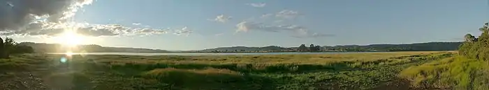
 View of Legana from Bridgenorth Road | |||||||||||||||
 Legana | |||||||||||||||
| Coordinates | 41°22′0″S 147°3′0″E | ||||||||||||||
| Population | 4,029 (2016)[1] | ||||||||||||||
| Postcode(s) | 7277 | ||||||||||||||
| Time zone | AEST (UTC+10) | ||||||||||||||
| • Summer (DST) | AEDT (UTC+11) | ||||||||||||||
| Location |
| ||||||||||||||
| LGA(s) | West Tamar | ||||||||||||||
| Region | Launceston | ||||||||||||||
| State electorate(s) | Bass | ||||||||||||||
| Federal Division(s) | Bass | ||||||||||||||
| |||||||||||||||
The name "Legana" is based on the Palawa word for "fresh water" since it is at the point where the Tamar River becomes fresh water. There is currently a homestead called "Freshwater" which was adjacent to a private jetty where early settlers traded with the local natives. This homestead, in Nobelius Drive, now operates as a Bed and Breakfast accommodation house.
History
Legana was originally a rural town made up of dairy farms, apple orchards, and cattle grazing. Most of the residences were originally located near the Tamar River with housing developments built nearer to the West Tamar Highway. Legana was also originally called Legana Estate. Legana was gazetted as a locality in 1963.[2]
Legana Post Office opened on 1 April 1910.[3]
Geography
The waters of the Tamar River estuary form the north-eastern, eastern and south-eastern boundaries.[4]
Road infrastructure
The West Tamar Highway (Route A7) passes through from south-east to north-west. Route C732 (Bridgenorth Road) starts at an intersection with A7 and runs west until it exits. Route C733 (Rosevears Drive) starts at an intersection with A7 and runs north until it exits.[2][5]
Community
Like most smaller rural townships, sporting clubs play an important part of the social life of Legana. Most of the community facilities are located within a community precinct which accommodates the Legana Cricket Club who compete in the TCL cricket competition running two teams, and although struggle they try hard, the Legana Tennis Club, and children's community playground, near the playground the council are planning to build a bicycle dirt jump park for the local youths to ride their bikes on. The memorial hall is near to this precinct. Legana has a Youth Group run by the West Tamar Council which is held at the memorial hall, allowing the youths to partake in afterschool activities and games.
A shopping centre has been built on the other side of this community precinct which provides the community with a supermarket and number of speciality shops. The shopping centre has had an upgrade and has been extended from the side and the back. Recently the area has had more developments in that businesses have decided to take advantage of this growing community: Legana now has a post office and a newsagent with Tatts Lotto, chemist, butcher, baker, hairdresser, KFC, Legana Tavern, BWS Bottle Shop, Legana Medical Centre, Launceston Holiday Park Caravan Park, Lawson Homes, Legana Bakery, Legana Plants Plus Nursery, Legana Hair & Beauty Salon, florist, R&R Caravan Centre, Reject Shop, Scotts Motorcycle Spares, Newman Automotive, Velo Vineyard, Impact kitchens, Salvation Army, St John's Foot Clinic, Tyres and More, Eyelines Glasses & Frames & Repairs, Harcourt's Real Estate, Woolworths, Woolworth's Petrol Plus, 2 ATM'S at Woolworths, as well as other new shops.
A fire station, Legana Fire Brigade consists of a group of enthusiastic volunteers who provide the community with a fire protection service equipped to respond to both structure and vegetation fires, car accidents, fire alarms. Legana Brigade was formed soon after the devastating 1967 bushfires in Tasmania. Legana Fire Brigade's first piece of equipment was a tanker trailer, purchased by the then Beaconsfield Council under a Rural Fires Board subsidy scheme, and housed at the Brigade Captain's property. At about this time the Legana area began to change from an agricultural base community to one of a rural residential nature with a sub-division at Freshwater Point. As a result, the Council provided a four-wheel drive medium tanker which again was housed at the Brigade Captain's As Legana' s population grew the existing members felt that the Fire Commission should provide a more suitable shed which was built in the early 80's. The members went further however and after much hard work, fund-raising and lobbying they were able to ensure that a meeting room and office were incorporated into the new station that was finally opened in 1985. The station was located on the old Freshwater Point Road but the developments of Grindelwald, Rosevears Danbury Park and the general expansion of Legana itself lead to plans being discussed in 1996 for a larger replacement station in a more central location.
Churches in Legana include the Legana Christian Church, a for profit business in Gerrard Close, and the Free Reformed Church in Outreach Drive.
Bus services
Legana has no schools, but is adequately serviced by several bus services for children to get to nearby schools. All bus services in Legana are run by Manions Buses. The "Legana Loop" route travels to and from Launceston.
Local government
Legana is a part of the West Tamar Municipality.
Notes and references
- "2016 Census Quick Stats Legana (Tas.)". quickstats.censusdata.abs.gov.au. Australian Bureau of Statistics. 23 October 2017. Retrieved 13 September 2020.
- "Placenames Tasmania – Legana". Placenames Tasmania. Retrieved 13 September 2020.
Select “Search”, enter 1082C, click “Search”, select row, map is displayed, click “Details”
- Premier Postal History. "Post Office List". Premier Postal Auctions. Retrieved 16 June 2012.
- Google (13 September 2020). "Legana, Tasmania" (Map). Google Maps. Google. Retrieved 13 September 2020.
- "Tasmanian Road Route Codes" (PDF). Department of Primary Industries, Parks, Water & Environment. May 2017. Archived from the original (PDF) on 1 August 2017. Retrieved 13 September 2020.
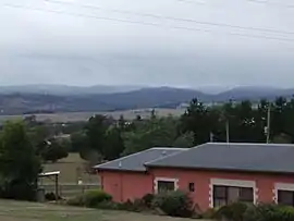
 The Legana Memorial Hall
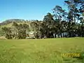 View from Legana
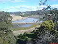 View near Legana