Les Authieux-Papion
Les Authieux-Papion is a former commune in the Calvados department in the Normandy region of north-western France. On 1 January 2017, it was merged into the new commune Mézidon Vallée d'Auge.[2]
Les Authieux-Papion | |
|---|---|
Part of Mézidon Vallée d'Auge | |
 | |
Location of Les Authieux-Papion 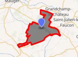
| |
 Les Authieux-Papion  Les Authieux-Papion | |
| Coordinates: 49°03′57″N 0°03′14″E | |
| Country | France |
| Region | Normandy |
| Department | Calvados |
| Arrondissement | Lisieux |
| Canton | Mézidon-Canon |
| Commune | Mézidon Vallée d'Auge |
| Area 1 | 4.28 km2 (1.65 sq mi) |
| Population (2017)[1] | 63 |
| • Density | 15/km2 (38/sq mi) |
| Time zone | UTC+01:00 (CET) |
| • Summer (DST) | UTC+02:00 (CEST) |
| Postal code | 14140 |
| Elevation | 30–79 m (98–259 ft) (avg. 59 m or 194 ft) |
| 1 French Land Register data, which excludes lakes, ponds, glaciers > 1 km2 (0.386 sq mi or 247 acres) and river estuaries. | |
Geography
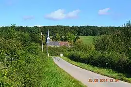
Les Authieux-Papion is located some 14 km south-west of Lisieux and 11 km north-east of Saint-Pierre-sur-Dives. The D47 road runs along the northern border of the commune from Mézidon-Canon in the west to join the D511 which runs down the eastern border of the commune from Saint-Julien-le-Faucon in the north-east to Saint-Pierre-sur-Dives in the south-west. Access to the village is by local roads off these two roads. There is a large forest towards the south (the Bois des Authieux) and another large forest in the north with the rest of the commune farmland.[3]
The Viette river flows through the centre of the commune from east to west as it flows west then north to join the Vie at Le Mesnil-Mauger.[3]
Neighbouring communes and villages[3] | |
|---|---|
Administration
List of Successive Mayors[4]
| From | To | Name | Party | Position |
|---|---|---|---|---|
| 1979 | 2017 | Jean-Pierre Perthuis |
(Not all data is known)
Demography
In 2017 the commune had 63 inhabitants.
|
| |||||||||||||||||||||||||||||||||||||||||||||||||||||||||||||||||||||||||||||||||||||||||||||||||||||||||||||||
| Source: EHESS[5] and INSEE[6] | ||||||||||||||||||||||||||||||||||||||||||||||||||||||||||||||||||||||||||||||||||||||||||||||||||||||||||||||||
Sites and monuments
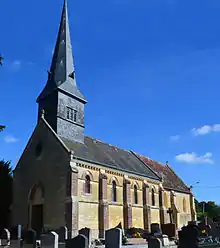
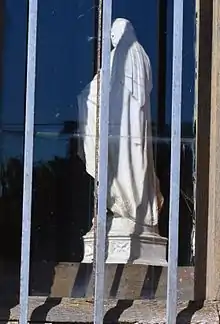
In the Parish Church of Saint-Philbert there is a Statue: Virgin and child (15th century)![]() which is registered as an historical object.[7]
which is registered as an historical object.[7]
See also
References
- Téléchargement du fichier d'ensemble des populations légales en 2017, INSEE
- Arrêté préfectoral 16 September 2016 (in French)
- Google Maps
- List of Mayors of France (in French)
- Données Cassini, EHESS
- Populations légales 2012, INSEE
- Ministry of Culture, Palissy PM14000029 Statue: Virgin and child (in French)

| Wikimedia Commons has media related to Les Authieux-Papion. |
| Authority control |
|---|