Leshem (Israeli settlement)
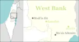
Leshem (Hebrew: לֶשֶם) is a religious Israeli settlement, which is also organized as a community village in western Samaria. It is located on Route 446, about 25 km (16 miles) east of Tel Aviv and about 37 km (23 miles) northwest of Jerusalem. Leshem is neighbored by the Israeli settlements of Alei Zahav, Peduel, Bruchin, Beit Aryeh-Ofarim, the archeological site of Deir Samaan, and the Palestinian villages Rafat, Kafr ad-Dik, and Deir Ballut.
Leshem
לֶשֶם | |
|---|---|
 Leshem's Overview | |
 Leshem | |
| Coordinates: 32°4′11″N 35°3′4″E | |
| Country | Israel |
| District | Judea and Samaria Area |
| Council | Shomron |
| Region | West Bank |
| Affiliation | Hapoel HaMizrachi |
| Founded | 2013 |
| Name meaning | Gem Stone |
| Website | http://myleshem.co.il |
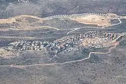
Leshem settlement rises to a height of 360 meters (1181.1 feet) above sea level and is stretched across two hills, the eastern hill and the western hill which altogether cover about 497 dunam (122.811 acres).
The international community considers Israeli settlements in the West Bank illegal under international law, but the Israeli government dispute this.[1]
History
In 1999, Lubavitcher Chassidim expressed their interest in putting down roots in what is known today as the western hill of Leshem, and shortly after building permits had been acquired, construction of a new settlement started. The settlement was named Adanim.
In 2020, Leshem was one of several Israeli settlement which dumped its untreated sewage onto Deir Ballut land.[2]
References
- "The Geneva Convention". BBC News. 10 December 2009. Retrieved 27 September 2011.
- 'Paradise lost': How Israel turned the West Bank into a sewage dump for its settlements, By Shatha Hammad, 21 October 2020, Middle East Eye