Leytonstone
Leytonstone /ˈleɪtənˌstoʊn/ is an area in East London, and part of the London Borough of Waltham Forest. It is a suburban area, located seven miles north-east of Charing Cross in Greater London. It borders Walthamstow to the north-west, Wanstead (in the London Borough of Redbridge) to the east, Stratford and Leyton to the south west and west respectively, and Forest Gate (in the London Borough of Newham) to the south. The area is served by Leytonstone tube station on the Central line & Leytonstone High Road on London Overground's Gospel Oak to Barking line. The northern end of Leytonstone High Road, beside Wanstead Flats, is known as Bushwood.
| Leytonstone | |
|---|---|
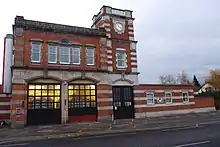
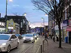 Leytonstone High Road | |
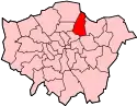
 Leytonstone Location within Greater London | |
| Population | 12,879 (2011 Census. Ward)[1] |
| OS grid reference | TQ3987 |
| London borough | |
| Ceremonial county | Greater London |
| Region | |
| Country | England |
| Sovereign state | United Kingdom |
| Post town | LONDON |
| Postcode district | E11, E15 |
| Dialling code | 020 |
| Police | Metropolitan |
| Fire | London |
| Ambulance | London |
| UK Parliament | |
| London Assembly | |
History
Origins and Roman milestone
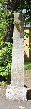
The main thoroughfare, Leytonstone High Road, is part of an ancient highway from Epping to London, on the borders of Epping Forest. A small hamlet at Leytonstone had existed since the early 14th century, when it formed part of the parish of Leyton in the county of Essex. The name Leytonstone, originally "Leyton-atte-Stone", comes from a distance marker called the High Stone, which stands at the junction of Hollybush Hill (the A1199 road with Woodford) and New Wanstead (the A113 road with Woodford Bridge), near the eastern bounds of the parish. It is a restored 18th-century obelisk set up on an earlier stump, traditionally described as a Roman milestone, possibly marking an extension of the Roman road from Dunmow to Chigwell into London.[2] Two of the obelisk inscriptions are still just legible, others not:
- "To Epping XI Miles through Woodford, Loughton"
- "To Ongar XV Miles through Woodford Bridge, Chigwell, Abridge"
Other Roman archaeological features have been found in the Leyton area, including "a Roman cemetery south of Blind Lane, and massive foundations of some Roman building, with quantities of Roman brick... discovered in the grounds of Leyton Grange."[3]
18th century
In 1722, author Daniel Defoe travelled through "Layton-stone, a place by some known, now as much, by the sign of the Green-Man". Leytonstone, along with Stratford, Leyton and Woodford, was one of the villages Defoe called as desirable country retreats for wealthy merchants and financiers within an easy ride of the City.[4]
19th century
Leytonstone remained largely rural until the opening of the railway at Leytonstone station in 1856, which gave quick and easy access to Stratford and central London. This, with increased availability of office and industrial work, had transformed the area into a suburban dormitory town by the end of the 19th century.
However, the forest land in the north and east of Leytonstone escaped development following a prolonged public campaign, when the Epping Forest Act 1878 preserved more than 200 acres (80 hectares) of open space for public use.[2]
In 1898 the department store Bearmans, opened by Frank Bearman to sell furniture and clothing, was the first store outside central London with an escalator.
20th century
In the 1960s, congestion around the shopping streets in Leytonstone[2] led to a one-way system being introduced. In the 1990s the M11 link road was built through the area despite a long-running protest by locals and road protestors. This and other protests led to the policy, Roads for Prosperity, being abandoned.[5]
Governance
Leytonstone belonged originally to the ancient parish of Leyton in the Becontree Hundred of Essex. It became a separate ecclesiastical parish in 1845.[6] The parish of Leyton formed part of the West Ham Poor law union. In 1894 it became part of Leyton Urban District, which was incorporated in 1926 as the Municipal Borough of Leyton.
Leytonstone became part of the London Borough of Waltham Forest in 1965 when Greater London was created.[7] Within the borough, it divides into four council wards, each with three councillors: Forest ward (Whipps Cross area, parts of Upper Leytonstone as far as Grove Green), Leytonstone ward (the rest of Upper Leytonstone, the town centre, Bushwood and Ferndale areas), Cathall ward and Cann Hall ward (South Leytonstone areas).[8]
The area forms part of the Leyton and Wanstead parliamentary constituency. As of May 2010, John Cryer has held the seat for the Labour Party. For elections to the London Assembly it is part of the North East constituency and the AM is Jennette Arnold of the Labour Party.[8]
Transport
Leytonstone tube station is in London Transport Zone 3 on the Central line of the London Underground, and serves as the last stop before the line splits into the Fairlop Loop and the branch to Epping (Zone 6). Since 2016, night tube trains run on Friday and Saturdays on the Central line every 10 minutes between White City and Leytonstone.[9] A series of tiled mosaics commemorating the local film director Alfred Hitchcock line the entrance passages to the station.[10]
Leytonstone High Road is a separate London Overground railway station, some 10 mins walk from the tube station, serving the line known colloquially as the GoBlin (Gospel Oak to Barking). In 2017–2018, the line was electrified ready for new longer trains with an additional 30 per cent capacity. After engineering and supply delays, these were finally introduced in June 2019.[11]
Leytonstone bus station stands either side of Leytonstone tube station. Buses include the 257 to Stratford, the W15 to Hackney, and the night bus N8 to Tottenham Court Road.
At the southern end of Leytonstone lies Maryland railway station – soon to be a Crossrail station, with much of the work to prepare the station for the Elizabeth Line completed.[12] This section of the Elizabeth Line, between Shenfield in Essex and Liverpool Street, was due to begin operating in late 2021–early 2022.
Leytonstone lies close to the foot of the M11 motorway to Cambridge, but within the ring formed by the North Circular and South Circular Roads. The Mayor of London announced that the capital's Ultra-Low Emission Zone (ULEZ) would be expanded up to the North and South Circular boundary in 2021.[13]
Education
Leytonstone schools include:
- Davies Lane Primary School, first opened in 1901 as a board school. In 1948 it became a junior and infants school, merging into a single primary in 2004. Among its famous alumni is the TV chat show host Jonathon Ross.
- George Tomlinson Primary School
- Gwyn Jones Primary School
- Mayville Primary School
- Buxton School, an all-through school for ages 3–16 and Specialist Science College
- Connaught School for Girls, a specialist language school
- Leytonstone School, a specialist business and enterprise school
- Norlington School, a boys' school and mixed sixth form
Notable features
- St John the Baptist's Church, Leytonstone is Grade II listed. Built in 1832 and consecrated in 1833, it is a landmark church at junction of High Road Leytonstone and Church Lane.[14] The churchyard is host to the regular vintage Stones Throw Market and Hitchcock's Home screenings[15] of Alfred Hitchcock Films on a 30-foot outdoor screen, as part of the annual Leytonstone Festival.
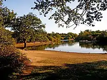
 The Temple, Wanstead Park
 - St Andrew's Church, Leytonstone, Grade II listed, was built in 1886–1893 as a memorial to the local philanthropist William Cotton and designed by Sir Arthur Blomfield.
- Wanstead Park lies in the former grounds of Wanstead House. It includes ornamental lakes, a temple-style folly and a grotto.
- Epping Forest reaches Leytonstone in wooded areas called Hollow Ponds and Wanstead Flats.
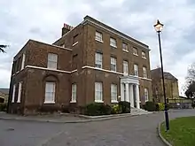
- Leytonstone House, an 18th-century, Grade II-listed home of Sir Edward Buxton, MP and conservationist, who with his brother played a big part in preserving Epping, Hainault and Hatfield forests. It housed Bethnal Green School for juvenile poor from 1868 to 1936.
- Leytonstone Library – a Grade II*listed art deco building built in 1934 to the design of James Ambrose Dartnall – underwent s £1.5-million refurbishment completed in 2015.[16]
- Whipps Cross University Hospital is set for redevelopment to include a brand new hospital, along with new homes and other communal facilities. It was selected as one of six UK hospitals to receive a share in £2.7bn of initial government funding in 2019.[17]
- Dagenham & Redbridge football club, currently playing in Sky Bet League Two, is an amalgamation of several amateur clubs, including Leytonstone F.C., who played along Leytonstone High Road. The Wanderers F.C. also originated from Leytonstone but played in several other venues round London.
Public services
Thames Water supplies Leytonstone's water. EDF Energy Networks is the Distribution network operator licensed to distribute electricity from the transmission grid to Leytonstone.
Whipps Cross University Hospital, in Whipps Cross road, is a University Hospital administered by Whipps Cross University Hospital NHS Trust. London Ambulance Service responds to medical emergencies in Leytonstone. Home Office policing in Leytonstone is provided by the Metropolitan Police Service.
The statutory emergency fire service is provided by the London Fire Brigade, with Leytonstone Fire Station in Leytonstone High Road. The original Victorian building of Leytonstone Fire Station was demolished and replaced in February 2016.
Sports
Leytonstone is home to the North Star Velo cycling club.North Star Velo 5K Parkruns take place in Wanstead Flats every week.home |Wanstead Flats parkrun |Wanstead Flats parkrun
Overseen by City of London Corporation, 60 football pitches – including eight full size – are located on Wanstead Flats and amateur football teams from Leytonstone play every Sunday.
Leytonstone Leisure Centre in Cathall Road, consists of a state-of-the-art gym on two floors, a 25-metre main pool, a teaching pool, two badminton court sports halls, fitness class studios, and an indoor soft-play area for under sixes.[18]
Leytonstone was home to the former association football team Leytonstone F.C. before it merged with Redbridge Forest F.C.. It last played in the Isthmian League in the 1978–79 season.
Notable people
.jpg.webp)
- Damon Albarn (born 1968), singer-songwriter born in Fillebrook Road. A blue plaque was erected in 2014 after an impromptu performance of "Park Life" at the Red Lion, Leytonstone High Road.[19]
- Eric Ashby, Baron Ashby (1904–1992), botanist, was born in Leytonstone.
- Roger Ashton-Griffiths (born 1957), actor
- David Bailey (born 1939), CBE, photographer, was born in Leytonstone.
- Reginald Poynton Baker (1896–1985), movie producer, father of the Conservative MP Peter Baker
- Ashley Banjo (born 1988), dancer and choreographer, was born in Leytonstone.
- David Beckham OBE (born 1975), footballer (England), was born in Leytonstone and grew up in Chingford.
- James Bevan (1858-1938), captain of the Welsh rugby union team in its first international match, died in Leytonstone
- Reginald Horace Blyth (1898–1964), author and orientalist
- Alan Booth (1946–1993), travel writer[20]
- Edward North Buxton (1840–1924), conservationist and liberal politician
- Cornelius Cardew (1936–1981), composer
.jpg.webp)
- Carly Cole (born 1984), model, fitness trainer and wife of footballer Joe Cole
- Fanny Cradock (1909–1994), TV chef and cookery writer born in Fairlop Road, Leytonstone[21]
- Curtis Davies (born 1985), footballer
- Cartrain (born 1991), artist
- Harris Dickinson (born 1996), actor
- Frank Dobson (1886–1963), sculptor, lived in Cobden Road as a teenager in 1901
- John Drinkwater (1882–1937), poet and dramatist, born in Leytonstone in 1882
- Charles Eade (1903–1964), journalist, born in Leytonstone
- Eamon Everall (born 1948), artist and educator
- Ken Farnes (1911–1941), cricketer
- Henry Charles Fehr (1867–1940), sculptor, lived and worked in Leytonstone in 1886–1891.[22]
- Joanne Fenn (born 1974), Olympic runner
- Stuart Freeborn (1914–2013), film make-up artist, born in Grove Green Road, had a Blue Heritage Plaque placed on his former home in December 2015.[23]
- Graham Gooch (born 1953), OBE, cricketer, former captain of the England cricket team
- Steve Harris (born 1956), founder and bassist of the band Iron Maiden
.jpg.webp)
.jpg.webp)
- Sir Alfred Hitchcock (1899–1980), film director born and raised in the area. The entrance to Leytonstone tube station has mosaics of scenes from his films. Next to his birth site at 517 Leytonstone High Road, the station has been painted with a mural of birds, repeated in the pavement outside, as a nod to Hitchcock's film, The Birds. A pub at 692 Leytonstone High Road was renamed The Birds.
- Tom Hood (1935–1974), humorist and playwright
- Sydney Horler (1888–1964), novelist
- Gavin Hoyte (born 1990), footballer
- Justin Hoyte (born 1984), footballer
- Derek Jacobi (born 1938) CBE, actor
- Jammer (born 1982), record producer
- Colin Kazim-Richards (born 1986), footballer
- Lucy Kirkwood (born 1983), playwright and screenwriter
- Don Law (1902–1982), record producer
- Natasha Little (born 1969), actor
- Seán Mac Stíofáin (1928–2001), chief-of-staff of the Provisional IRA
- Morell Mackenzie (1837–1892), research physician
- Colin Matthews (born 1946), composer
- Dominic McVey (born 1985), Britain's youngest self-made millionaire
- Jozef Piłsudski (1867–1935), Polish statesman, stayed with the Wasilewski family while on the run from Russia in the 1900s
- Jamie Porter (born 1993), cricketer
- Redzz (born 1987), rapper, actor, songwriter and musician
- Tony Robinson (born 1946), comedian and broadcaster
- Jonathan (born 1960), broadcaster and comedian
- Paul Ross (born 1956), broadcaster
- June Sarpong (born 1977) MBE, television presenter
- Rita Simons (born 1977), actress, singer and model
- Talvin Singh (born 1970), composer and musician
- Adam Smith (born 1991), footballer
- Bob and Roberta Smith (born 1963), artist, writer and musicians, pseudonym of Patrick Brill
- Harold Spurr (1889–1962), English cricketer
- Andros Townsend (born 1991), footballer
- Halszka Wasilewska (1899–1961), soldier, daughter of Leon Wasilewski, spent her infancy here before becoming a decorated major in the Polish Armed Forces
- Leon Wasilewski (1870–1936), Polish political activist and editor lived in Leytonstone in 1898–1903
- Douglas Webb (1922–1996), photographer
In drama, film and television
- In The Bed-Sitting Room (1969), Spike Milligan created the (fictional) closest heir to the British throne after the outbreak of nuclear war as "Mrs. Ethel Shroake" of 393A High Street, Leytonstone. She appears in the final scene of the play.
- Deep End, a 1970 horror film, was partly shot at the old Cathall Road Baths in Leytonstone.[24]
- Small Potatoes was a 1999 TV sitcom made by Hat Trick Productions for Channel 4, about the young manager of a video shop in Leytonstone.[25]
- I Proud to Be an Indian was a 2004 Bollywood film, about an Indian family in late 1970s Leytonstone terrorised by skinheads.
- In EastEnders, Kim Fox is from Leytonstone.
See also
References
- "Waltham Forest Ward population 2011". Neighbourhood Statistics. Office for National Statistics. Retrieved 19 October 2016.
- Powell, W. R. (1973). "A History of the County of Essex". British History Online. pp 174–184, Leyton: Introduction. Retrieved 26 March 2018.
- J. Kennedy A History of the Parish of Leyton, Essex Phelp Brothers, Leyton (1894), digital copy at [archive.org].
- Defoe, Daniel (1722), A tour thro' the whole island of Great Britain, divided into circuits or journies (Volume I, Letter I)
- Lean, Geoffrey (21 January 1996). "Tories ditch the 'car economy'". The Independent. London. Retrieved 7 May 2010.
- Hibbert, Christopher (2008). London Encyclopaedia. Macmillan London Ltd. pp. 482–483. ISBN 978-1-4050-4924-5.
- Powell, W. R., ed. (1973). A History of the County of Essex: Volume 6. London: Victoria County History. pp. 205–214. ISBN 978-0197227190.
- "Leytonstone Democracy". leytonstonetoday.net. L D Horton. Retrieved 22 June 2020.
- Matters, Transport for London | Every Journey. "The Night Tube". Transport for London. Retrieved 29 April 2017.
- "Alfred Hitchcock Tile Murals in Tube Station".
- Ian Visits. "Ian Visits".
- TFL Crossrail. "TFL Crossrail Maryland Station".
- "Mayor Of London Press Release ULEZ (low emission zone) expansion to expand up to North and South Circular".
- "Welcome to St Johns". www.stjohns-leytonstone.org.uk. Retrieved 29 April 2017.
- "Hitchcock's Home – Leytonstoner".
- "East London Guardian – History: The Leytonstone Library that became 'a symbol of freedom and democracy' in war propaganda". East London Guardian.
- Barts Health NHS. "Future Whipps Cross Hospital".
- "Leytonstone Leisure Centre".
- "BBC Damon Albarn sings Park Life In Red Lion Pub, Leytonstone".
- "Alan Booth". The Times (64580). 1 March 1993. p. 19.
- "Blue Plaque – Fanny Craddock".
- "Famous people who came from our area". www.leytonpast.info. Leyton & Leytonstone Historical Society. Retrieved 26 March 2018.
- ITV News. "Star Wars Artist Honoured With Plaque on East London House". ITV News.
- Deep End filming locations at IMDb
- "Hat Trick Featured shows". www.hattrick.co.uk.
External links
| Wikimedia Commons has media related to Leytonstone. |
- The Leytonstoner – a community news magazine and review website
- Leytonstone Arts Trail – annual arts event in Leytonstone
- Woodhouse Players – an amateur drama group located in Leytonstone
- Bushwood Area Residents' Association BARA – neighbourhood group for the Bushwood Area of Leytonstone
- Ferndale Area Residents' Association FARA – neighbourhood group for the Ferndale Area of Leytonstone
- Forest Residents' Association Leytonstone FORA – neighbourhood group for the Forest Area of Upper Leytonstone
- – a Leytonstone community website
- The Leytonstone War Memorial Project
- The Friends of Wanstead Parkland – Wanstead Parklands, expansive green space adjacent to Leytonstone
- Archives relating to Leytonstone at The National Archives (United Kingdom)
| Districts |
|  |
|---|---|---|
| Attractions |
| |
| Street markets | ||
| Parks and open spaces |
| |
| Constituencies |
| |
| Tube and rail stations | ||
| Other topics | ||
| ||